IMAGES TAKEN NEAR TO
Haygrove Lane, SHEPTON MALLET, BA4 4FX
Introduction
This page details the photographs taken nearby to Haygrove Lane, BA4 4FX by members of the Geograph project.
The Geograph project started in 2005 with the aim of publishing, organising and preserving representative images for every square kilometre of Great Britain, Ireland and the Isle of Man.

There are currently over 7.5m images from over14,400 individuals and you can help contribute to the project by visiting https://www.geograph.org.uk
Image Map
Images are licensed for reuse under creativecommons.org/licenses/by-sa/2.0
Notes
- Clicking on the map will re-center to the selected point.
- The higher the marker number, the further away the image location is from the centre of the postcode.
Image Listing (9 Images Found)
Images are licensed for reuse under creativecommons.org/licenses/by-sa/2.0
Image
Details
Distance
1
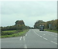
2009 : A361 heading east, half a mile from Leighton
A minor road heads south at this point taking a different route to Batcombe.
Image: © Maurice Pullin
Taken: 26 Oct 2009
0.02 miles
3
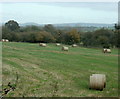
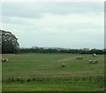
2009 : Field with straw bales off the A361
West of Leighton.
Cley Hill is to the left about 10 miles over. Image
Image: © Maurice Pullin
Taken: 26 Oct 2009
0.04 miles
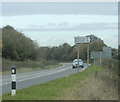
4
2009 : A361 heading west to Dean, Doulting and Shepton Mallet
Cockpit Lane leaves the main road to the south for Batcombe.
Image: © Maurice Pullin
Taken: 26 Oct 2009
0.10 miles
5
2009 : Swiss rolls in a field near Leighton
Waiting for the farmer to collect them when he has run out of better things to do.
Seen from the A361.
The little blip on the horizon is Alfred's Tower Image
Image: © Maurice Pullin
Taken: 26 Oct 2009
0.11 miles
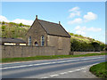
6
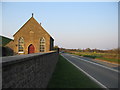
Leighton Chapel
A view looking to the northeast along the A361 towards Leighton Chapel. As far as I am aware, the building is no longer used for religious purposes.
Image: © Phil Williams
Taken: 1 Apr 2007
0.22 miles
7
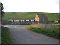
Approaching Leighton
A view looking to the northwest towards the A361 at Leighton. The building on the right is a now disused chapel. The large mound in the background is part of the overburden removed from the extension of the Torr Works quarry, prior to quarrying operations.
Image: © Phil Williams
Taken: 1 Apr 2007
0.23 miles
8
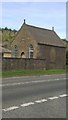
Former chapel, Leighton
This humble and grimy building with a tin roof now appears to be absorbed into the farmyard buildings of Chapel Farm. Once a Primitive Methodist chapel, it is dated 1863, so the roof is not original.
Image: © Robin Webster
Taken: 2 Apr 2017
0.24 miles