IMAGES TAKEN NEAR TO
Westholme Road, SHEPTON MALLET, BA4 4EB
Introduction
This page details the photographs taken nearby to Westholme Road, BA4 4EB by members of the Geograph project.
The Geograph project started in 2005 with the aim of publishing, organising and preserving representative images for every square kilometre of Great Britain, Ireland and the Isle of Man.

There are currently over 7.5m images from over14,400 individuals and you can help contribute to the project by visiting https://www.geograph.org.uk
Image Map
Images are licensed for reuse under creativecommons.org/licenses/by-sa/2.0
Notes
- Clicking on the map will re-center to the selected point.
- The higher the marker number, the further away the image location is from the centre of the postcode.
Image Listing (78 Images Found)
Images are licensed for reuse under creativecommons.org/licenses/by-sa/2.0
Image
Details
Distance
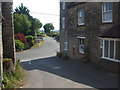
2
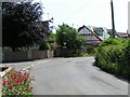
Pilton village centre
The small village of Pilton is located on the main A361 between Glastonbury and Shepton Mallet
Image: © Paul Anderson
Taken: 4 Nov 2006
0.02 miles
3
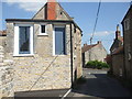
A high rise home?
This building has two doors on the second floor, apparently with no means of easy access. The left one not only has a handle but a Yale lock too. The answer to this oddity lies with the fresh stone wall below the doors: a few years ago this building had an upper floor outside them, but which has now been demolished. Hopefully the occupants remember...
Image: © Neil Owen
Taken: 30 May 2020
0.03 miles
4
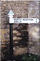
Direction Sign ? Signpost
Located against the north wall of Toll Cottage on the north side of the junction of the A361 Park Hill / Whitstone Hill in Pilton parish. 1 arm and pyramid finial. This is a replacement, the original was smashed by a lorry.
Milestone Society National ID: SO_ST5840A
Image: © R Raynsford
Taken: 19 Jan 2020
0.06 miles
5
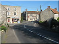
Down Totterdown Lane
A road down into the heart of Pilton, passing the pub and old post office at the junction with the main road. A flush bracket is set into the corner of the latter building - see Image
Image: © Neil Owen
Taken: 30 May 2020
0.06 miles
6
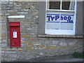
The leftovers from the service
Pilton was served by this post office for almost all the twentieth century before finally stamping its last letter. These two relics remain to keep a little bit of the history.
Image: © Neil Owen
Taken: 30 May 2020
0.07 miles
7
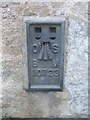
Flush bracket on the old Pilton Post Office
A more modern number on the benchmark, dating from post-WWII, on the former post office at the junction on the A361, Whitstone Hill. See Image] for a wider view and https://www.bench-marks.org.uk/bm18786 for the entry in the Benchmark Database.
Image: © Neil Owen
Taken: 30 May 2020
0.07 miles
8
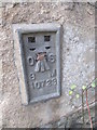
Ordnance Survey Flush Bracket (10723)
This OS Flush Bracket can be found on the former Post Office. It marks a point 70.624m above mean sea level.
Image: © Adrian Dust
Taken: 23 Nov 2014
0.07 miles
9
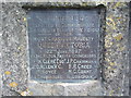
Plaque of the Victorian Tree
A small and easily overlooked plaque at the junction of the A361 Whitstone Hill and Shop Lane tells of the planting of a tree in 1897. See Image] for a wider view.
Image: © Neil Owen
Taken: 30 May 2020
0.07 miles
10
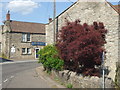
Some colourful but short trees
At the junction opposite the pub is a small walled patch of land. In it are some attractively coloured trees and shrubs. However, a plaque on the wall refers to a commemorative tree planted in 1897 - which, unless it is a really slow grower, must have gone from this spot. See Image] for a look at the plaque.
Image: © Neil Owen
Taken: 30 May 2020
0.07 miles