IMAGES TAKEN NEAR TO
Lower Street, SHEPTON MALLET, BA4 4DD
Introduction
This page details the photographs taken nearby to Lower Street, BA4 4DD by members of the Geograph project.
The Geograph project started in 2005 with the aim of publishing, organising and preserving representative images for every square kilometre of Great Britain, Ireland and the Isle of Man.

There are currently over 7.5m images from over14,400 individuals and you can help contribute to the project by visiting https://www.geograph.org.uk
Image Map
Images are licensed for reuse under creativecommons.org/licenses/by-sa/2.0
Notes
- Clicking on the map will re-center to the selected point.
- The higher the marker number, the further away the image location is from the centre of the postcode.
Image Listing (10 Images Found)
Images are licensed for reuse under creativecommons.org/licenses/by-sa/2.0
Image
Details
Distance

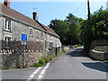
3

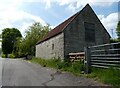
2011 : Cottages at the southern end of Neat Lane
On the eastern edge of Pilton.
Image: © Maurice Pullin
Taken: 11 Jun 2011
0.10 miles
5
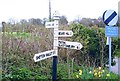
Old Direction Sign - Signpost by East Town Lane, Pilton parish
Pyramid finial - 4 arms; Somerset SCC pyramid by the UC road, in parish of Pilton (Mendip District), East Town Lane junction with Platterwell Lane, Neat Lane and Top Street, on verge.
Surveyed
Milestone Society National ID: SO_ST5940A
Image: © Milestone Society
Taken: Unknown
0.11 miles
6
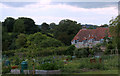
2011 : Allotments seen from John Burns Close
Off Neat Lane.
East of Pilton.
Image: © Maurice Pullin
Taken: 11 Jun 2011
0.12 miles
7

New Houses Neat Lane
This small modern estate of semi detached houses has been built recently on the north east side of Pilton just off Neat Lane.
Image: © Nigel Mykura
Taken: 18 Sep 2011
0.13 miles
8
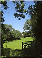
Field, Pilton
A glimpse from Pylle Lane of a little L-shaped meadow at the edge of the village.
Image: © Derek Harper
Taken: 22 Jul 2012
0.22 miles
10
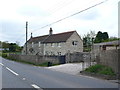
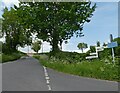
House on Whitstone Hill
This is the A361 which rises up from Pilton north easterly on the way to Shepton Mallet. This cottage seemed to have a modern extension almost as big as the original house.
Image: © Nigel Mykura
Taken: 14 Apr 2012
0.24 miles