IMAGES TAKEN NEAR TO
Bread Street, SHEPTON MALLET, BA4 4BQ
Introduction
This page details the photographs taken nearby to Bread Street, BA4 4BQ by members of the Geograph project.
The Geograph project started in 2005 with the aim of publishing, organising and preserving representative images for every square kilometre of Great Britain, Ireland and the Isle of Man.

There are currently over 7.5m images from over14,400 individuals and you can help contribute to the project by visiting https://www.geograph.org.uk
Image Map
Images are licensed for reuse under creativecommons.org/licenses/by-sa/2.0
Notes
- Clicking on the map will re-center to the selected point.
- The higher the marker number, the further away the image location is from the centre of the postcode.
Image Listing (79 Images Found)
Images are licensed for reuse under creativecommons.org/licenses/by-sa/2.0
Image
Details
Distance
1
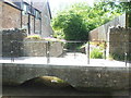
Downstream to Whitelake
The ford in Ford Lane, with pedestrian access over the bridge.
Image: © Neil Owen
Taken: 30 May 2020
0.06 miles
2
The ford in Ford Lane
Quiet after an especially dry Spring.
Image: © Neil Owen
Taken: 30 May 2020
0.06 miles
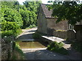
3

Pilton Ford
This ford is found on the aptly named Ford Lane at Pilton.
Image: © John Walton
Taken: 18 Mar 2016
0.06 miles
5

Old Direction Sign - Signpost by Pylle Road, Pilton parish
Pyramid finial - 3 arms; Somerset SCC pyramid by the UC road, in parish of Pilton (Mendip District), Pylle Road junction with Hitchin Hill, Worthy Lane, on verge, East side of road.
Surveyed
Milestone Society National ID: SO_ST5940B
Image: © Milestone Society
Taken: Unknown
0.08 miles
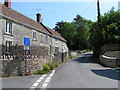
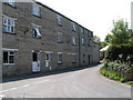
7
Buildings at Pilton
Benleigh Cottages are between Pylle Road (foreground) and Hitchen Hill.
Image: © Derek Harper
Taken: 22 Jul 2012
0.11 miles
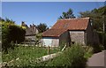
8

Tithe barn, Pilton
The structure dates back to the 14th century when it was then one of four such barns attached to Glastonbury Abbey. After the Reformation it became a working farm building until 1963 when it was struck by lightning which destroyed the thatched roof, leaving only the four walls.
Image: © Maigheach-gheal
Taken: 18 Sep 2009
0.12 miles
9
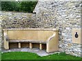
Memorial seat, Pilton
In the grounds of the tithe barn is a memorial seat to the Women's Land Army of both World Wars.
Image: © Maigheach-gheal
Taken: 18 Sep 2009
0.12 miles
10
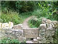
Stile, Pilton
The stile allows access to the footpath that takes walkers to the Tithe Barn.
Image: © Maigheach-gheal
Taken: 18 Sep 2009
0.12 miles