IMAGES TAKEN NEAR TO
High Street, SHEPTON MALLET, BA4 4AA
Introduction
This page details the photographs taken nearby to High Street, BA4 4AA by members of the Geograph project.
The Geograph project started in 2005 with the aim of publishing, organising and preserving representative images for every square kilometre of Great Britain, Ireland and the Isle of Man.

There are currently over 7.5m images from over14,400 individuals and you can help contribute to the project by visiting https://www.geograph.org.uk
Image Map
Images are licensed for reuse under creativecommons.org/licenses/by-sa/2.0
Notes
- Clicking on the map will re-center to the selected point.
- The higher the marker number, the further away the image location is from the centre of the postcode.
Image Listing (47 Images Found)
Images are licensed for reuse under creativecommons.org/licenses/by-sa/2.0
Image
Details
Distance
1
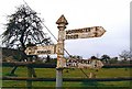
Old Direction Sign - Signpost by High Street, North Wootton
Pyramid finial - 3 arms; Somerset SCC pyramid by the UC road, in parish of North Wootton (Mendip District), Dark Lane junction with High Street.
Surveyed
Milestone Society National ID: SO_ST5641G
Image: © Milestone Society
Taken: Unknown
0.05 miles
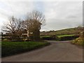
3
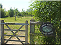
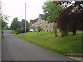
An open space for North Wootton
An otherwise undeveloped field is now the village green.
Image: © Neil Owen
Taken: 30 May 2020
0.07 miles
4
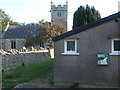
An AED on the village hall
North Wootton village hall has a defibrillator, which was humming constantly due to some sort of extraction fan in its case. The tower of St Peter's church looks on.
Image: © Neil Owen
Taken: 30 May 2020
0.07 miles
5
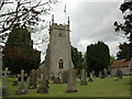
St Peter's Church, North Wootton
St Peter's Church, North Wootton with Worminster (Worminster being about 1km north of North Wootton).
Image: © Aidan Simons
Taken: 12 Aug 2007
0.07 miles
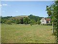
6
North Wootton village green
Occupying a large field opposite the church, it has plenty of trees.
Image: © Neil Owen
Taken: 30 May 2020
0.07 miles
7
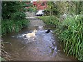
Stream, North Wootton
The village is situated at the entrance of a valley watered by two small rivulets, which turn several mills, one being employed for grinding bark for a tannery. Here the dogs take a cooling dip in one of them.
Image: © Maigheach-gheal
Taken: 20 Sep 2009
0.07 miles
8
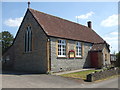
North Wootton village hall
Built in 1906 and refurbished in 2006. The stone above the door reads 'The Right Only Shall Endure', the hall opened by Bishop Stirling, Saturday 28th July, 1906.
Image: © Neil Owen
Taken: 30 May 2020
0.07 miles
9
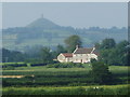
Glastonbury Tor seen from North Wootton
You can see the Tor rising from the flat meadows near Glastonbury from miles around.
Image: © Nigel Freeman
Taken: 2 Aug 2005
0.07 miles
10
North Wootton - Crossroads Hotel
Enlarged hotel big enough for weddings and larger functions in this small village.
Image: © Nigel Freeman
Taken: 2 Aug 2005
0.07 miles