IMAGES TAKEN NEAR TO
Moorwood, RADSTOCK, BA3 5BN
Introduction
This page details the photographs taken nearby to Moorwood, BA3 5BN by members of the Geograph project.
The Geograph project started in 2005 with the aim of publishing, organising and preserving representative images for every square kilometre of Great Britain, Ireland and the Isle of Man.

There are currently over 7.5m images from over14,400 individuals and you can help contribute to the project by visiting https://www.geograph.org.uk
Image Map
Images are licensed for reuse under creativecommons.org/licenses/by-sa/2.0
Notes
- Clicking on the map will re-center to the selected point.
- The higher the marker number, the further away the image location is from the centre of the postcode.
Image Listing (4 Images Found)
Images are licensed for reuse under creativecommons.org/licenses/by-sa/2.0
Image
Details
Distance
1
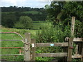
Footpath from T'other Side The Hill
The path leads from the stile here at T'other Side The Hill. It goes to the other side of the valley.
Image: © Neil Owen
Taken: 20 Aug 2020
0.04 miles
2
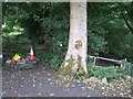
A footpath fork
Two options - both have a common starting point at the tree. The left path goes to Gurneyslade Bottom.
Image: © Neil Owen
Taken: 20 Aug 2020
0.08 miles
3
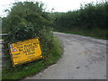
Thanks for the warning
This roadworks notice ought to be removed by now - it is August.
Image: © Neil Owen
Taken: 20 Aug 2020
0.24 miles
4
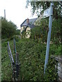
Blocked at Moon's Bottom
The footpath looks like it is not the most frequently used. Walkers may need to take extra care - or are more likely to take blackberries.
Image: © Neil Owen
Taken: 20 Aug 2020
0.25 miles