IMAGES TAKEN NEAR TO
Benter, Oakhill, RADSTOCK, BA3 5BJ
Introduction
This page details the photographs taken nearby to BA3 5BJ by members of the Geograph project.
The Geograph project started in 2005 with the aim of publishing, organising and preserving representative images for every square kilometre of Great Britain, Ireland and the Isle of Man.

There are currently over 7.5m images from over14,400 individuals and you can help contribute to the project by visiting https://www.geograph.org.uk
Image Map
Images are licensed for reuse under creativecommons.org/licenses/by-sa/2.0
Notes
- Clicking on the map will re-center to the selected point.
- The higher the marker number, the further away the image location is from the centre of the postcode.
Image Listing (5 Images Found)
Images are licensed for reuse under creativecommons.org/licenses/by-sa/2.0
Image
Details
Distance
2
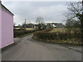
Direction Sign - Signpost by Upper Benter, Ashwick
Lost finial - 1 arm; Somerset SCC pyramid by the UC road, in parish of Ashwick (Mendip District), Upper Benter, by farm.
Surveyed
Milestone Society National ID: SO_ST6449A
Image: © Milestone Society
Taken: 15 Feb 2013
0.10 miles
3
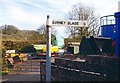
Thanks for the warning
This roadworks notice ought to be removed by now - it is August.
Image: © Neil Owen
Taken: 20 Aug 2020
0.13 miles
4
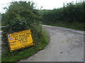
Fly Tipping at Middle Wood
Middle Wood is adjacent to a narrow lane that runs north from the B3356 at Sweetleaze Farm towards Chilcommpton. There is obviously a fly tipping problem because of the large number of signs prohibiting such activity.
Image: © Nigel Mykura
Taken: 19 Dec 2020
0.23 miles
5
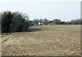
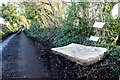
2009 : Maize stubble seen from Sweet Leaze Lane
Maize is one of the last crops to be harvested, in a wet season this may not give enough time for ploughing before the following spring.
Image: © Maurice Pullin
Taken: 22 Mar 2009
0.23 miles