IMAGES TAKEN NEAR TO
Brewery Lane, RADSTOCK, BA3 5AT
Introduction
This page details the photographs taken nearby to Brewery Lane, BA3 5AT by members of the Geograph project.
The Geograph project started in 2005 with the aim of publishing, organising and preserving representative images for every square kilometre of Great Britain, Ireland and the Isle of Man.

There are currently over 7.5m images from over14,400 individuals and you can help contribute to the project by visiting https://www.geograph.org.uk
Image Map
Images are licensed for reuse under creativecommons.org/licenses/by-sa/2.0
Notes
- Clicking on the map will re-center to the selected point.
- The higher the marker number, the further away the image location is from the centre of the postcode.
Image Listing (24 Images Found)
Images are licensed for reuse under creativecommons.org/licenses/by-sa/2.0
Image
Details
Distance
1
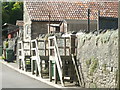
Wooden steps to the houses
Almost every house has a set of wooden steps to the back. They were originally built for the workers at the malthouse opposite and shaved their commute by seconds!
Image: © Neil Owen
Taken: 20 Aug 2020
0.05 miles
2
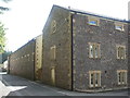
The old malthouses
Oakhill's history is steeped in brewing. Many of the village's larger buildings were involved in the trade in one form or another, especially when noted the chequered fortunes of the businesses over time. The old malthouses here were working from the mid eighteenth century onwards right up until 2004 (although the present structures dates from the late nineteenth). Since then the buildings have been extensively adapted to provide residential opportunities.
Image: © Neil Owen
Taken: 20 Aug 2020
0.08 miles
3
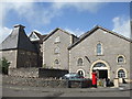
A malthouse in outline
The old malthouses in Oakhill operated and brewed from 1767, when Jordan and Perkins first founded the Oakhill Brewery. Soon after it was taken over by a local man, John Billingsley (1747-1811), who was multi-talented and also had dealings in engineering and agriculture. Throughout the next century the company was owned by the Jillard and Spencer families, with the Hobhouse family taking the reins into the twentieth.
The village benefited from the growth of the brewery and both shared in the supply of Mendip spring water, gas lighting and sewerage systems, and a light railway line to export the goods. The mainly Non-Conformist owners often gave land for chapels, the village school and even donated coal in harsh weathers.
The outbreak of WWI caused the authorities to restrict alcohol and the buildings suffered from two bad fires in the 1920s; the trade slumped accordingly - from then on the brewery changed hands several times and included a spell of closure. Smaller scale operations recommenced in 1981 and the ownership changed again a few times. Eventually, work finally stopped in 2004; the site was partly demolished and the main malthouse here was converted to residential use.
Image: © Neil Owen
Taken: 20 Aug 2020
0.11 miles
4
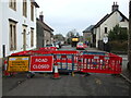
The High Street is closed
Oakhill is undergoing a couple of week's worth of road improvements.
Image: © Neil Owen
Taken: 17 Mar 2021
0.16 miles
5
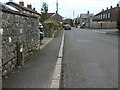
Little London High Street
A view down the main road with a water infrastructure marker post by the roadside. See Image] for a better look at the ageing item.
Image: © Neil Owen
Taken: 17 Mar 2021
0.17 miles
6
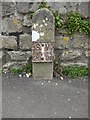
Sluice Valve marker
An old example of an everyday roadside piece of furniture. It is a cast version and is in old Imperial units. It must be decades old.
See Image] for a location view.
Image: © Neil Owen
Taken: 17 Mar 2021
0.17 miles
7
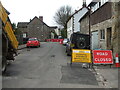
Road closed in Oakhill
Some road maintenance going on along the High Street.
Image: © Neil Owen
Taken: 17 Mar 2021
0.18 miles
8
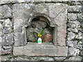
A theme on Zion Hill
This day was St Patrick's Day and someone seems to have made an apt display in a wall niche.
Image: © Neil Owen
Taken: 17 Mar 2021
0.18 miles
9
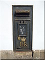
A black box on High Street
What else would you find on the old Post Office? In fact this building held the position for the latter part of the twentieth century before closing - previously the office was near the main road. The house itself dates from the mid-nineteenth century and is Grade II listed.
Image: © Neil Owen
Taken: 20 Aug 2020
0.18 miles