IMAGES TAKEN NEAR TO
Horne Close, RADSTOCK, BA3 4SS
Introduction
This page details the photographs taken nearby to Horne Close, BA3 4SS by members of the Geograph project.
The Geograph project started in 2005 with the aim of publishing, organising and preserving representative images for every square kilometre of Great Britain, Ireland and the Isle of Man.

There are currently over 7.5m images from over14,400 individuals and you can help contribute to the project by visiting https://www.geograph.org.uk
Image Map (Loading...)


Getting Data...Please wait
Leaflet Map data © OpenStreetMap
Images are licensed for reuse under creativecommons.org/licenses/by-sa/2.0
Notes
- Clicking on the map will re-center to the selected point.
- The higher the marker number, the further away the image location is from the centre of the postcode.
Image Listing (6 Images Found)
Images are licensed for reuse under creativecommons.org/licenses/by-sa/2.0
Image
Details
Distance
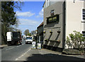
2
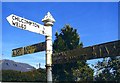
Direction Sign - Signpost on the A367 Fosseway, Stratton on the Fosse
Pyramid finial - 3 arms; Somerset SCC pyramid by the A367, in parish of Stratton on the Fosse (Mendip District), on the east side of the T junction of the A367 Fosseway and Green Lane.
surveyed
Milestone Society National ID: SO_ST6550B
Image: © Milestone Society
Taken: Unknown
0.14 miles
3
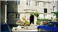
Downside School
I am a former pupil!
Image: © Ronald John Saunders
Taken: Unknown
0.17 miles
4
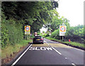
2010 : Kings Arms, Stratton-on-the-Fosse
Situated on the A367.
Seen from the other side in Image]
I hear they do an excellent carvery.
Image: © Maurice Pullin
Taken: 20 Apr 2010
0.22 miles
5
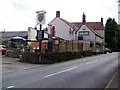
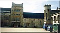
King's Arms, Stratton-on-the-Fosse
A local pub that does an excellent carvery.
Image: © Maigheach-gheal
Taken: 11 Jul 2009
0.24 miles