IMAGES TAKEN NEAR TO
Wells Road, RADSTOCK, BA3 4SP
Introduction
This page details the photographs taken nearby to Wells Road, BA3 4SP by members of the Geograph project.
The Geograph project started in 2005 with the aim of publishing, organising and preserving representative images for every square kilometre of Great Britain, Ireland and the Isle of Man.

There are currently over 7.5m images from over14,400 individuals and you can help contribute to the project by visiting https://www.geograph.org.uk
Image Map
Images are licensed for reuse under creativecommons.org/licenses/by-sa/2.0
Notes
- Clicking on the map will re-center to the selected point.
- The higher the marker number, the further away the image location is from the centre of the postcode.
Image Listing (14 Images Found)
Images are licensed for reuse under creativecommons.org/licenses/by-sa/2.0
Image
Details
Distance
1
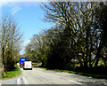
2010 : B3139 heading northeast to Chilcompton
At the junction with Redhill Lane, seen left.
Image: © Maurice Pullin
Taken: 20 Apr 2010
0.14 miles
2
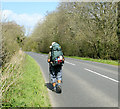
2010 : B3139 with a gentleman of the road
Not the old fashioned gentleman you understand, the modern variety. He told me he was walking from Lands End to John O' Groats - uphill all the way in this direction. Wished him well and told him about Geograph as he seemed interested.
If you should read this sir, hope your progress was good and thank you for your conversation.
Image: © Maurice Pullin
Taken: 20 Apr 2010
0.14 miles
3
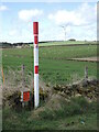
Gas and green energy
A gas pipeline marker with a more sympathetic source in the background.
Image: © Neil Owen
Taken: 17 Mar 2022
0.15 miles
4
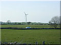
2009 : Pasture from Whitnell Lane
The car is on the B3139.
The wind generator also appears in Image
Image: © Maurice Pullin
Taken: 22 Mar 2009
0.17 miles
5
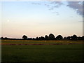
Farmland at dusk
Sheep grazing on the Mendip Plateau.
Image: © Sharon Loxton
Taken: 4 Jul 2009
0.19 miles
6
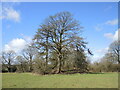
Trees on a tumulus
One of a number in the area, this bowl barrow is close to Emborough and is possibly believed to date back to the Bronze Age. It is about 32m in diameter and 2.5m high, with evidence of a berm surrounding it. The trees have shielded the outline somewhat. See Image] for another barrow north of this one.
Image: © Neil Owen
Taken: 17 Mar 2022
0.21 miles
7
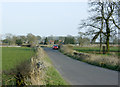
2009 ; Whitnell Lane
Heading east to Binegar. At the junction with the B3139.
Image: © Maurice Pullin
Taken: 22 Mar 2009
0.21 miles
8
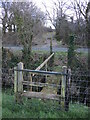
Getting to the Emborough road
The footpath crosses a field and this drainage ditch before reaching the main road. Fortunately, the barbed wire is sheathed at the appropriate point and the footstep is cleared of fence wire; it's not that accessible despite that.
Image: © Neil Owen
Taken: 17 Mar 2022
0.21 miles
9
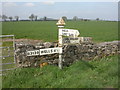
Binegar, fingerpost
Traditional Somerset fingerpost: tapering post with "SOMERSET" in raised letters, pyramid-shaped finial with "SCC" legend. At junction B3139 & Whitnell Lane. Note stationary wind turbine in the background.
Image: © Mike Faherty
Taken: 12 Apr 2009
0.21 miles
10
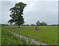
Isolated tree, south of Whitnell Lane
Image: © Roger Cornfoot
Taken: 31 Aug 2024
0.21 miles