IMAGES TAKEN NEAR TO
Dudwell Lane, RADSTOCK, BA3 4ND
Introduction
This page details the photographs taken nearby to Dudwell Lane, BA3 4ND by members of the Geograph project.
The Geograph project started in 2005 with the aim of publishing, organising and preserving representative images for every square kilometre of Great Britain, Ireland and the Isle of Man.

There are currently over 7.5m images from over14,400 individuals and you can help contribute to the project by visiting https://www.geograph.org.uk
Image Map
Images are licensed for reuse under creativecommons.org/licenses/by-sa/2.0
Notes
- Clicking on the map will re-center to the selected point.
- The higher the marker number, the further away the image location is from the centre of the postcode.
Image Listing (10 Images Found)
Images are licensed for reuse under creativecommons.org/licenses/by-sa/2.0
Image
Details
Distance
1
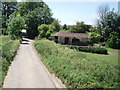
Barn and compound
An old, attractive looking stone barn and compound on Dudwell lane.
Image: © Sharon Loxton
Taken: 11 Jun 2006
0.01 miles
2
Slurry running down the road
Slurry is flowing down this road, it's running off the field on the right where it is currently being sprayed by a tractor which can be seen in the field behind one of the fence posts.
Image: © Philip Halling
Taken: 15 Feb 2018
0.10 miles
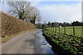
3
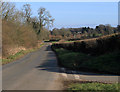
Road junction at Cutlers Green
Road junction at Cutlers Green near Chew Mendip.
Image: © Philip Halling
Taken: 15 Feb 2018
0.10 miles
4
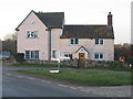
Cutlers Green
The road junction on the B3114 at Cutlers Green, with the pink house reflecting the late afternoon sunshine.
Image: © Phil Williams
Taken: 21 Jan 2006
0.13 miles
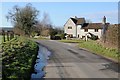
5
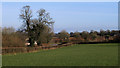
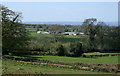
2012 : Over farmland near Puppy Cross Ways
Looking over neatly trimmed hedgerows toward Cutlers Green Farm and Cutler's Green.
Image: © Maurice Pullin
Taken: 26 Feb 2012
0.14 miles
6
Field near Bathway
It stank here at the moment this picture was taken. Slurry was being sprayed onto this field by a tractor out of picture to the left; it can be seen lying on the field, but the land is so wet at present that much of the slurry is running off the field into the road. What a stink!
Image: © Philip Halling
Taken: 15 Feb 2018
0.16 miles
7

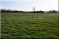
2012 : Open gate at Puppy Cross Ways
Looking north east over the Mendips beyond.
My guess, a flock of sheep on the way to enjoy the new grass. Cuttlers Green Farm is out of the frame to the right.
On OS Map 141 it is Cuttlers Green Farm near Cutler's Green.
Image: © Maurice Pullin
Taken: 26 Feb 2012
0.19 miles
8
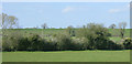
2010 : South west from Cole's Lane
Toward Dudwell Field Farm.
Image: © Maurice Pullin
Taken: 20 Apr 2010
0.20 miles
9
2012 : B3114 looking east from Puppy Cross Ways
About a quarter of a mile to Cutler's Green.
Image: © Maurice Pullin
Taken: 26 Feb 2012
0.20 miles
10
2010 : Franklyn's Farm seen from Redhill Lane
With the Mendip Hills in the distance.
Image: © Maurice Pullin
Taken: 20 Apr 2010
0.23 miles