IMAGES TAKEN NEAR TO
Parsonage Lane, RADSTOCK, BA3 4JU
Introduction
This page details the photographs taken nearby to Parsonage Lane, BA3 4JU by members of the Geograph project.
The Geograph project started in 2005 with the aim of publishing, organising and preserving representative images for every square kilometre of Great Britain, Ireland and the Isle of Man.

There are currently over 7.5m images from over14,400 individuals and you can help contribute to the project by visiting https://www.geograph.org.uk
Image Map
Images are licensed for reuse under creativecommons.org/licenses/by-sa/2.0
Notes
- Clicking on the map will re-center to the selected point.
- The higher the marker number, the further away the image location is from the centre of the postcode.
Image Listing (2 Images Found)
Images are licensed for reuse under creativecommons.org/licenses/by-sa/2.0
Image
Details
Distance
1
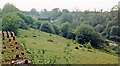
Site of Chilcompton station, 1987
View SW, towards Evercreech Junction, Templecombe and Bournemouth: ex-Midland & LSW (Somerset & Dorset) Joint line, Bath - Bournemouth West. This was on the long climb from Radstock to Masbury Summit; ahead was Chilcompton Tunnel. The whole line was closed on 7/3/66.
Image: © Ben Brooksbank
Taken: 5 May 1987
0.19 miles
2

Parsonage Lane, Chilcompton
The lane joins the main road as it leaves Chilcompton going westward.
Image: © HelenK
Taken: 15 Jun 2013
0.21 miles