IMAGES TAKEN NEAR TO
Station Mead, RADSTOCK, BA3 4FD
Introduction
This page details the photographs taken nearby to Station Mead, BA3 4FD by members of the Geograph project.
The Geograph project started in 2005 with the aim of publishing, organising and preserving representative images for every square kilometre of Great Britain, Ireland and the Isle of Man.

There are currently over 7.5m images from over14,400 individuals and you can help contribute to the project by visiting https://www.geograph.org.uk
Image Map
Images are licensed for reuse under creativecommons.org/licenses/by-sa/2.0
Notes
- Clicking on the map will re-center to the selected point.
- The higher the marker number, the further away the image location is from the centre of the postcode.
Image Listing (28 Images Found)
Images are licensed for reuse under creativecommons.org/licenses/by-sa/2.0
Image
Details
Distance
1
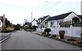
Houses in Bakers Lane
This is looking north along Bakers Lane away from the junction at the centre of the village with Naish's Cross. The road just visible on the left is the entrance to Sheppards Walk.
Image: © Nigel Mykura
Taken: 2 Nov 2020
0.07 miles
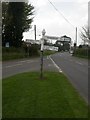
2

2010 : Baker's Lane, Chilcompton
A pleasant minor road heading north to Midsomer Norton.
Image: © Maurice Pullin
Taken: 10 May 2010
0.09 miles
3
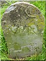
Old Boundary Marker by Bakers Lane, Chilcompton parish
Municipal Boundary Marker by Bakers Lane, in parish of Chilcompton (Mendip District), Broadway, at junction with the B3139, Wells Road.
Inscription reads:-
M N
D C
(Midsomer Norton District Council)
Somerset HER.
HER number: 39490 https://www.heritagegateway.org.uk/Gateway/Results_Single.aspx?uid=39490&resourceID=100
Surveyed
Milestone Society National ID: SO_MNDC01pb
Image: © Milestone Society
Taken: Unknown
0.09 miles
4
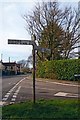
Old Direction Sign - Signpost by the B3139, Wells Road, Chilcompton Parish
Lost finial - 4 arms, 2 lost; Somerset SCC pyramid by the B3139, in parish of Chilcompton (Mendip District), junction of B3139 Wells Road with Bakers Lane, diagonally across crossroads from Co-op.
Surveyed
Milestone Society National ID: SO_ST6451C
Image: © Milestone Society
Taken: Unknown
0.09 miles
5
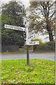
New Direction Sign - Signpost on the B3139 Wells Road in Chilcompton
Located on the northeast side of the crossroads of the B3139 Wells Road, Bakers Lane and Stockhill Road, diagonally opposite the Co-op in Chilcompton parish. 4 arms and pyramid finial. A completely new fingerpost in 2021 to replace the one shown in https://www.geograph.org.uk/photo/6043795.
Milestone Society National ID: SO_ST6451C
Image: © J Francis
Taken: 29 Oct 2021
0.09 miles
6

2010 : B3139 Wells Road, Chilcompton
Looking west. Meeting the B3356 a short distance ahead.
Image: © Maurice Pullin
Taken: 10 May 2010
0.10 miles
7

Site of Chilcompton station, 1987
View SW, towards Evercreech Junction, Templecombe and Bournemouth: ex-Midland & LSW (Somerset & Dorset) Joint line, Bath - Bournemouth West. This was on the long climb from Radstock to Masbury Summit; ahead was Chilcompton Tunnel. The whole line was closed on 7/3/66.
Image: © Ben Brooksbank
Taken: 5 May 1987
0.10 miles
8

2010 : Post Office and Co-operative Store, Chilcompton
At the corner of Wells Road and Stockhill Road.
Image: © Maurice Pullin
Taken: 10 May 2010
0.12 miles
9
Chilcompton, fingerpost 1
Traditional Somerset fingerpost: tapering pillar (slightly skew), freshly painted arms, pyramidal finial with "SCC". At junction B3139/B3356.
Image: © Mike Faherty
Taken: 12 Apr 2009
0.12 miles
10
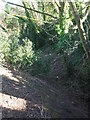
Filling in the steamy past
The railways came to Chilcompton in 1874 as part of the Somerset and Dorset Railway Company and left in 1966 under Dr Beeching. The track under the bridge has been largely filled in now, leaving a shady place for nature to return.
Image: © Neil Owen
Taken: 14 Feb 2019
0.13 miles