IMAGES TAKEN NEAR TO
Ston Easton, RADSTOCK, BA3 4DS
Introduction
This page details the photographs taken nearby to BA3 4DS by members of the Geograph project.
The Geograph project started in 2005 with the aim of publishing, organising and preserving representative images for every square kilometre of Great Britain, Ireland and the Isle of Man.

There are currently over 7.5m images from over14,400 individuals and you can help contribute to the project by visiting https://www.geograph.org.uk
Image Map (Loading...)


Getting Data...Please wait
Leaflet Map data © OpenStreetMap
Images are licensed for reuse under creativecommons.org/licenses/by-sa/2.0
Notes
- Clicking on the map will re-center to the selected point.
- The higher the marker number, the further away the image location is from the centre of the postcode.
Image Listing (23 Images Found)
Images are licensed for reuse under creativecommons.org/licenses/by-sa/2.0
Image
Details
Distance

2
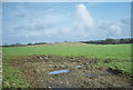
Tumulus near Ston Easton
Image: © Dominic Dawn Harry and Jacob Paterson
Taken: 18 Feb 2006
0.04 miles
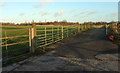
4
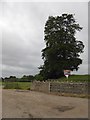
Drive to North Lawn, outside Ston Easton
This gate also marks the start of a footpath to Rush Hill, Farrington Gurney
Image: © David Smith
Taken: 10 Jun 2017
0.10 miles
5
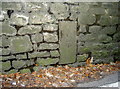
Benchmark on a stone in a wall
The cutmark on Ston Easton High Street appears to have been specially chosen. See Image] for a wider view and http://www.bench-marks.org.uk/bm80666 for the entry in the Benchmark Database.
Image: © Neil Owen
Taken: 28 Nov 2016
0.11 miles
6

A long way to Gloster
This milepost is a familiar triangular shape, detailing the distances to important towns:
Bristol - 13
Shepton Mallet - 7
Gloster - 48
Note the makers decided not to spell it Gloucester!
Image: © Neil Owen
Taken: 28 Nov 2016
0.11 miles
7
Entrance road to North Lawn Cottage
Looking right from Image] along the private drive. Footpath CL 19/12 leaves on the left for Rush Hill Wood. The trees are along the edge of the golf course at Farrington Golf and Country Club.
Image: © Derek Harper
Taken: 9 Dec 2019
0.11 miles
8

Old Milepost by the A37, High Street, Ston Easton
The milestone is located in the village on the pavement against a stone wall, on the north side of road. Parish of Ston Easton (Mendip District). Cast iron post, plated iron casting design, erected by the Shepton Mallet turnpike trust in the 19th century.
Inscription reads:-
SHEPTON / MALLET / 7 : : GLOSTER / 48 : : BRISTOL / 13
Grade II listed, List Entry Number: 1058669
https://historicengland.org.uk/listing/the-list/list-entry/1058669
Milestone Society National ID: SO_SMBR07
Image: © JR Dowding
Taken: Unknown
0.11 miles
9

NEW
Old Milepost by the A37, High Street, Ston Easton
The milestone is located in the village on the pavement against a stone wall, on the north side of road. Parish of Ston Easton (Mendip District). Cast iron post, plated iron casting design, erected by the Shepton Mallet turnpike trust in the 19th century.
Inscription reads:-
SHEPTON / MALLET / 7 : : GLOSTER / 48 : : BRISTOL / 13
Grade II listed, List Entry Number: 1058669
https://web.archive.org/web/20210116180434/https://historicengland.org.uk/listing/the-list/list-entry/1058669
Milestone Society National ID: SO_SMBR07
Image: © Neil Blacker
Taken: 26 Aug 2025
0.11 miles
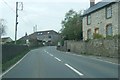
10

Ston Easton High Street
Otherwise known as the A37. The back of Clare Hall looms over it. For a milepost see Image], and for a benchmark see Image
Image: © Neil Owen
Taken: 28 Nov 2016
0.11 miles