IMAGES TAKEN NEAR TO
Lower Bristol Road, BATH, BA2 9ER
Introduction
This page details the photographs taken nearby to Lower Bristol Road, BA2 9ER by members of the Geograph project.
The Geograph project started in 2005 with the aim of publishing, organising and preserving representative images for every square kilometre of Great Britain, Ireland and the Isle of Man.

There are currently over 7.5m images from over14,400 individuals and you can help contribute to the project by visiting https://www.geograph.org.uk
Image Map
Images are licensed for reuse under creativecommons.org/licenses/by-sa/2.0
Notes
- Clicking on the map will re-center to the selected point.
- The higher the marker number, the further away the image location is from the centre of the postcode.
Image Listing (52 Images Found)
Images are licensed for reuse under creativecommons.org/licenses/by-sa/2.0
Image
Details
Distance
1
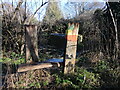
In the path of the Emperor
A small and unofficial-looking marker states that the former Ethiopian ruler, Haile Selassie, walked this riverside path during his time here. Selassie was exiled and lived in Bath from 1936-41, living in nearby Fairfield House - a residence he bought and donated to the city when he left.
Image: © Neil Owen
Taken: 20 Jan 2023
0.04 miles
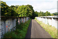
2
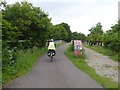
Bristol and Bath cycle path crossing River Avon
The Bristol and Bath cycle path follows a former railway line
Image: © David Smith
Taken: 10 Jun 2017
0.05 miles
3
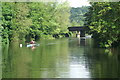
River Avon above Newbridge Railway Bridge
Looking downstream to the former rail bridge now used by the Bristol and Bath Railway Path. This section of the river has much rowing activity.
Image: © Pierre Terre
Taken: 20 May 2006
0.05 miles
4
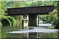
River Avon, Newbridge Railway Bridge
Now used by the Bristol to Bath cycle and footpath.
Image: © Pierre Terre
Taken: 20 May 2006
0.05 miles
5
Bridge over the River Avon
The Bristol and Bath Railway Path uses a former railway from which it is not possible to get any view of the river.
Image: © Bill Boaden
Taken: 28 Sep 2017
0.05 miles
6
![Newbridge Railway Bridge [No 207], from the north-west](https://s2.geograph.org.uk/geophotos/04/48/37/4483738_afc9f5c4_120x120.jpg)
Newbridge Railway Bridge [No 207], from the north-west
Now carrying the Bristol & Bath Railway Path over the River Avon.
Image: © Christine Johnstone
Taken: 3 May 2015
0.06 miles
7
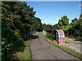
Bridge over the river Avon on the Bristol and Bath Railway Path
Image: © Rob Purvis
Taken: 25 Aug 2018
0.08 miles
8
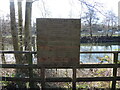
Poetry on the banks
A wooden board bears a bit of poetry. It read:
'The River Avon, by Carrie Etter
In tree-shadow, on a dirt path,
we walk in the cool
alongside the river.
A crow perches on a post,
a heron on the opposite bank
perfects stillness, slows
our pace. Overhead,
in the green boughs, twitter
and chirp, rustle andtwitch
the river brims with wings.
For a long hour
we loiter. We thrive.'
Image: © Neil Owen
Taken: 20 Jan 2023
0.08 miles
9
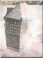
Old Boundary Marker by the A36, Lower Bristol Road
Parish Boundary Marker - Turnpike by the A36, in parish of Bath (Bath And North East Somerset District), Lower Bristol Road, Bath, East of junction of A4 and A36, on pavement against the parapet of Newton Brook bridge.
Inscription reads:-
: NEWTON / ST. LOE : : 1827 / BATH TURNPIKE TRUST : : TWERTON :
Surveyed
Milestone Society National ID: SO_BAWMpb
Image: © Milestone Society
Taken: Unknown
0.08 miles
10
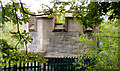
Tower at Twerton Railway Tunnel
One of two over the tunnel entrance. Built C1840 on the Great Western Line between Bath and Bristol.
Image: © Rick Crowley
Taken: 23 Jul 2020
0.10 miles