IMAGES TAKEN NEAR TO
Padleigh Hill, BATH, BA2 9DW
Introduction
This page details the photographs taken nearby to Padleigh Hill, BA2 9DW by members of the Geograph project.
The Geograph project started in 2005 with the aim of publishing, organising and preserving representative images for every square kilometre of Great Britain, Ireland and the Isle of Man.

There are currently over 7.5m images from over14,400 individuals and you can help contribute to the project by visiting https://www.geograph.org.uk
Image Map
Images are licensed for reuse under creativecommons.org/licenses/by-sa/2.0
Notes
- Clicking on the map will re-center to the selected point.
- The higher the marker number, the further away the image location is from the centre of the postcode.
Image Listing (29 Images Found)
Images are licensed for reuse under creativecommons.org/licenses/by-sa/2.0
Image
Details
Distance
1

Houses on Padleigh Hill
Padleigh Hill is the steep hill where the Englishcombe road descends into a steep sided valley that marks the south western limit of Bath's urban sprawl. The opposite slopes of the valley are topped by the ancient Wansdyke so it was a significant boundary for centuries.
Image: © Nigel Mykura
Taken: 30 Sep 2012
0.00 miles
2

Public footpath to Rush Hill
A view looking to the southeast from Englishcombe Lane towards the public footpath to Rush Hill.
Image: © Phil Williams
Taken: 13 Mar 2007
0.03 miles
3
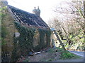
The remains of Woodland Cottage
A view looking to the southwest along Englishcombe Lane towards the burnt out shell of Woodland Cottage.
Image: © Phil Williams
Taken: 13 Mar 2007
0.04 miles
4

Woodland Cottage
This cottage was photographed five years previously https://www.geograph.org.uk/photo/364742 and not much has changed to the burnt out cottage except that the ivy now covers the complete building to the tops of the chimneys.
Image: © Nigel Mykura
Taken: 30 Sep 2012
0.06 miles
5
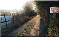
Track from Padleigh Hill
Connecting to footpath BA 11/5#2 towards the Newton Brook valley, and seen from the same spot as Image
Image: © Derek Harper
Taken: 16 Feb 2016
0.07 miles
6
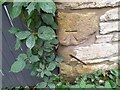
Ordnance Survey Cut Mark
This OS cut mark can be found on Woodland Cottage. It marks a point 77.224m above mean sea level.
Image: © Adrian Dust
Taken: 16 Nov 2022
0.07 miles
7

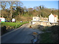
Frosty field below Southdown
From a path that links Padleigh Hill to footpath BA 11/5#2 - it may even be part of the latter, though it's not mapped a such. This looks uphill across pasture land to where two terraces of houses have been built on the site of the Jubilee Inn - see http://www.geograph.org.uk/search.php?i=61129652 .
Image: © Derek Harper
Taken: 16 Feb 2016
0.07 miles
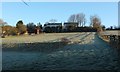
8
Englishcombe Lane
A view looking to the northeast along Englishcombe Lane as it crosses the small bridge over a tributary of Newton Brook.
Image: © Phil Williams
Taken: 13 Mar 2007
0.08 miles
9
Frosty field below Southdown
The fence, and the terraced houses on the site of the Jubilee Inn, can also be seen in Image
Image: © Derek Harper
Taken: 16 Feb 2016
0.11 miles
10

Houses on Rush Hill
Although it's not a hill along this stretch, approaching the junction with Padleigh Hill and Englishcombe Lane.
Image: © Derek Harper
Taken: 16 Feb 2016
0.13 miles