IMAGES TAKEN NEAR TO
The Barton, BATH, BA2 9AL
Introduction
This page details the photographs taken nearby to The Barton, BA2 9AL by members of the Geograph project.
The Geograph project started in 2005 with the aim of publishing, organising and preserving representative images for every square kilometre of Great Britain, Ireland and the Isle of Man.

There are currently over 7.5m images from over14,400 individuals and you can help contribute to the project by visiting https://www.geograph.org.uk
Image Map
Images are licensed for reuse under creativecommons.org/licenses/by-sa/2.0
Notes
- Clicking on the map will re-center to the selected point.
- The higher the marker number, the further away the image location is from the centre of the postcode.
Image Listing (37 Images Found)
Images are licensed for reuse under creativecommons.org/licenses/by-sa/2.0
Image
Details
Distance
2
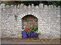
Cut benchmark, Corston
The cutmark is listed on the Benchmark Database: http://www.bench-marks.org.uk/bm37049.
See Image] for wider view.
Image: © Neil Owen
Taken: 18 Feb 2011
0.10 miles
3
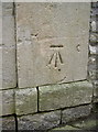
Entrance to St Teresa's Nursing Home, Corston
This former convent is now a highly appointed care home for the elderly. On the right hand side is a cut benchmark as listed in the database http://benchmarks.ordnancesurvey.co.uk/pls/htmldb/f?p=111:3:589717760497752108::NO::P3_HIDDEN:true.
See Image] for a close view
Image: © Neil Owen
Taken: 18 Feb 2011
0.10 miles
4
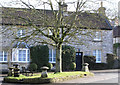
Corston Triangle
This grass triangle is very close to the Post Office. Notice the staddle stones which were once used to support granaries above the ground thereby protecting the stored grain from vermin and water seepage. The house on the right of the terrace is called the old bakery.
Image: © Rick Crowley
Taken: 21 Feb 2010
0.10 miles
5
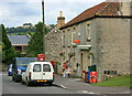
2008 : Corston Post Office and greengrocery
The road links the A36 and the A4.
Kelston Round Hill is on the skyline. Image
Image: © Maurice Pullin
Taken: 8 Sep 2008
0.11 miles
6
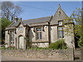
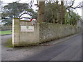
Corston's old school
This modern private residence was the National School for the village, opened 1844. The foundation stone was laid by Mrs Simpson, the vicar's wife and witnessed by a handful of local dignitaries. A speech, composed by the Rev. Simpson and approved by the Chancellor, was read; the Hundredth Psalm was sung and the school opened up to the many children of the labouring classes.
Image: © Neil Owen
Taken: 18 Apr 2017
0.11 miles
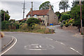
8
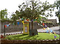
New tree, old village
This small traffic island has the bunting out for the annual fete. But the tree in the centre is a sapling that replaces an old elm that used to stand here - the Hanging Tree. It is commemorated by a small plaque (see Image] ) as the tree associated with the sweeping retributions following the Monmouth Rebellion of 1685.
Image: © Neil Owen
Taken: 21 Jul 2012
0.12 miles
9
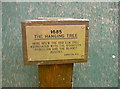
The Hanging Tree
Small brass plaque marking the place where an ancient tree was rooted. See Image] for a wider view.
Image: © Neil Owen
Taken: 21 Jul 2012
0.12 miles
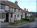
10
House at Corston
The main road is the A39, the lane to the right is Ashton Hill.
Image: © J.Hannan-Briggs
Taken: 31 Jul 2014
0.12 miles