IMAGES TAKEN NEAR TO
Shaft Road, BATH, BA2 7HP
Introduction
This page details the photographs taken nearby to Shaft Road, BA2 7HP by members of the Geograph project.
The Geograph project started in 2005 with the aim of publishing, organising and preserving representative images for every square kilometre of Great Britain, Ireland and the Isle of Man.

There are currently over 7.5m images from over14,400 individuals and you can help contribute to the project by visiting https://www.geograph.org.uk
Image Map
Images are licensed for reuse under creativecommons.org/licenses/by-sa/2.0
Notes
- Clicking on the map will re-center to the selected point.
- The higher the marker number, the further away the image location is from the centre of the postcode.
Image Listing (15 Images Found)
Images are licensed for reuse under creativecommons.org/licenses/by-sa/2.0
Image
Details
Distance

2
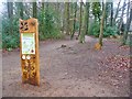
Bath - Fairy Wood
Nature trail on Bath's Skyline Walk, locally known for its collection of tiny doors at the foot of some trees.
Image: © Colin Smith
Taken: 28 Mar 2015
0.16 miles
3
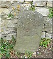
Old Boundary Marker by North Road, Bath parish
Parish Boundary Marker by the UC road, in parish of Bath (Bath and North East Somerset District), North Road, at entrance to park against left hand wall.
Surveyed
Milestone Society National ID: SO_WID02pb
Image: © Milestone Society
Taken: Unknown
0.16 miles
4

Old Boundary Marker on North Road, Bath
Parish Boundary Marker against a stone wall next to the park entrance on the north side of the junction of North Road and Shaft Road in Bath. Inscribed P / L AND W / 189…. On the former boundary of Lyncombe and Widcombe parish, which became part of Bath parish in 1900. Similar stones are dated 1894. See also https://www.geograph.org.uk/photo/6094896.
Milestone Society National ID: SO_WID01pb
Image: © Roadside Relics
Taken: 16 May 2023
0.17 miles
5
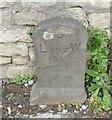
Old Boundary Marker by North Road, Bath
Parish Boundary Marker by the UC road, in an parished area of Bath and North East Somerset District, North Road, opposite junction with Shaft Road, next to park entrance, against wall. On the former boundary of Lyncombe and Widcombe parish, which became part of Bath parish in 1900.
Inscription reads:-
P
L AND W
18??
Surveyed
Milestone Society National ID: SO_WID01pb
Image: © M Faherty
Taken: 18 Jul 2011
0.17 miles
6

Scilla flowers carpeting the woodland in the grounds of Bath Clinic
Image: © Rod Allday
Taken: 16 Mar 2019
0.17 miles

8
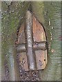
Bath - Fairy Door
One of some 20 "fairy doors" for visitors to look out for at the bottom of trees in Fairy Wood. They are about 4-6 inches high.
Image: © Colin Smith
Taken: 28 Mar 2015
0.19 miles
9

Footpath in Fairy Wood
Part of the Bath Skyline walk. There is evidence in the wood of numerous previous excavations.
Image: © Bill Boaden
Taken: 29 Jul 2016
0.21 miles
10

BMI Bath Clinic
A private hospital on the edge of Claverton Down.
Image: © Rod Allday
Taken: 16 Mar 2019
0.21 miles