IMAGES TAKEN NEAR TO
Copseland, BATH, BA2 6EA
Introduction
This page details the photographs taken nearby to Copseland, BA2 6EA by members of the Geograph project.
The Geograph project started in 2005 with the aim of publishing, organising and preserving representative images for every square kilometre of Great Britain, Ireland and the Isle of Man.

There are currently over 7.5m images from over14,400 individuals and you can help contribute to the project by visiting https://www.geograph.org.uk
Image Map
Images are licensed for reuse under creativecommons.org/licenses/by-sa/2.0
Notes
- Clicking on the map will re-center to the selected point.
- The higher the marker number, the further away the image location is from the centre of the postcode.
Image Listing (37 Images Found)
Images are licensed for reuse under creativecommons.org/licenses/by-sa/2.0
Image
Details
Distance
1
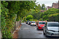
Bath : Copseland
Looking along Copseland.
Image: © Lewis Clarke
Taken: 6 Aug 2020
0.02 miles
2
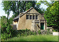
Former hall, Claverton Down Road, Bath
Attractive and distinctive former Gospel Hall, built in 1896-97 and designed by Silcock & Reay. Penty of quirky Arts and Crafts details. Grade II listed.
Now a private house.
Image: © Stephen Richards
Taken: 20 Jun 2017
0.02 miles
3

Footpath only on the private road
A non-standard looking sign on Quarry Farm, with a delightful patina.
Image: © Neil Owen
Taken: 14 May 2020
0.05 miles
4

Quarry Farm - a private drive
This shared path takes users past the former Claverton Down Quarries. The site is now largely residential.
Image: © Neil Owen
Taken: 14 May 2020
0.05 miles
5
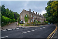
Bath : Widcombe Hill
Looking along Widcombe Hill.
Image: © Lewis Clarke
Taken: 6 Aug 2020
0.06 miles
6
Bath : Oakley
Looking along a road through Bath.
Image: © Lewis Clarke
Taken: 6 Aug 2020
0.07 miles
7
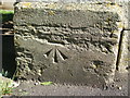
A benchmark at the top of Bathwick Hill
A fine cutmark, as listed in the Benchmark Database: https://www.bench-marks.org.uk/bm121058 , remains in very good condition despite its age of well over a century - a nod to the high quality of the Bath stone used here. See Image] for a wider view of the house entrance.
Image: © Neil Owen
Taken: 14 May 2020
0.07 miles
8
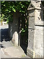
Benchmark by The Rectory
A benchmark lies on the entrance pier at the house at the junction of several roads at the top of Bathwick Hill. The inscription is The Rectory, although the residence is now known as Osbourne House. Previously it appears to have been called The Beeches. See Image] for a closer look at the cutmark.
Image: © Neil Owen
Taken: 14 May 2020
0.08 miles
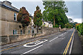
9

Bath : Road
A road heads to Widcombe Hill.
Image: © Lewis Clarke
Taken: 6 Aug 2020
0.08 miles
10
Bath : Clarence Terrace
Looking towards homes on Clarence Terrace.
Image: © Lewis Clarke
Taken: 6 Aug 2020
0.08 miles