IMAGES TAKEN NEAR TO
Church Street, BATH, BA2 6BA
Introduction
This page details the photographs taken nearby to Church Street, BA2 6BA by members of the Geograph project.
The Geograph project started in 2005 with the aim of publishing, organising and preserving representative images for every square kilometre of Great Britain, Ireland and the Isle of Man.

There are currently over 7.5m images from over14,400 individuals and you can help contribute to the project by visiting https://www.geograph.org.uk
Image Map
Images are licensed for reuse under creativecommons.org/licenses/by-sa/2.0
Notes
- Clicking on the map will re-center to the selected point.
- The higher the marker number, the further away the image location is from the centre of the postcode.
Image Listing (75 Images Found)
Images are licensed for reuse under creativecommons.org/licenses/by-sa/2.0
Image
Details
Distance
1
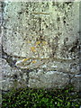
Benchmark on wall of Church Lane
Ordnance Survey cut mark benchmark described on the Bench Mark Database at http://www.bench-marks.org.uk/bm35420.
Image: © Roger Templeman
Taken: 3 Sep 2010
0.02 miles
2
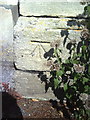
Benchmark on former gatepost on NE side of Church Lane
Ordnance Survey cut mark benchmark described on the Bench Mark Database at http://www.bench-marks.org.uk/bm35425.
Image: © Roger Templeman
Taken: 3 Sep 2010
0.04 miles
3
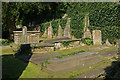
Widcombe Churchyard
Very small packed churchyard squeezed between St Thomas a Becket church and Church Lane.
Image: © Stephen McKay
Taken: 20 Sep 2008
0.05 miles
4
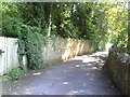
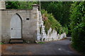
Church Lane
Looking southwards along the lane
Image: © Roger Templeman
Taken: 3 Sep 2010
0.06 miles
5
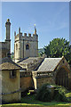
St Thomas a Becket Church, Widcombe
This small church dates from the 1490s.
Image: © Stephen McKay
Taken: 20 Sep 2008
0.06 miles
6
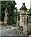
Gate piers, Church Street, Bath
At the entrance to Widcombe Manor (Image]) and probably contemporary with it. Wrought-iron gates flanked by rusticated piers topped with castellations or crowns and lions (or other unspecified angry beast). Grade I listed.
Image: © Stephen Richards
Taken: 18 Jun 2018
0.06 miles
7

Benchmark on gatepost on east side of Church Lane
Ordnance Survey cut mark benchmark described on the Bench Mark Database at http://www.bench-marks.org.uk/bm35406. The gateway is shown at Image
Image: © Roger Templeman
Taken: 3 Sep 2010
0.07 miles
8
Gothic doorway in Church Lane, Widcombe
Image: © David Martin
Taken: 6 Jul 2016
0.07 miles
9
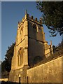
Church of St Thomas a Becket, Widcombe
The church gets the briefest of mentions at http://www.britishlistedbuildings.co.uk/en-442441-church-of-st-thomas-a-becket-bath . Pevsner (1958) gives more detail. The church dates originally from 1499, but was remodelled in the C18 and C19.
Image: © Derek Harper
Taken: 11 Feb 2012
0.07 miles
10
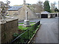
View of Widcombe War Memorial from Church Lane
Looking north-northwest.
Image: © Robert Lamb
Taken: 15 Apr 2012
0.07 miles