IMAGES TAKEN NEAR TO
Southstoke Road, BATH, BA2 5SP
Introduction
This page details the photographs taken nearby to Southstoke Road, BA2 5SP by members of the Geograph project.
The Geograph project started in 2005 with the aim of publishing, organising and preserving representative images for every square kilometre of Great Britain, Ireland and the Isle of Man.

There are currently over 7.5m images from over14,400 individuals and you can help contribute to the project by visiting https://www.geograph.org.uk
Image Map
Images are licensed for reuse under creativecommons.org/licenses/by-sa/2.0
Notes
- Clicking on the map will re-center to the selected point.
- The higher the marker number, the further away the image location is from the centre of the postcode.
Image Listing (31 Images Found)
Images are licensed for reuse under creativecommons.org/licenses/by-sa/2.0
Image
Details
Distance
1
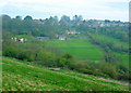
2008 : Top end of Horsecombe Vale
Houses in Combe Down gather round the top of the slope like spectators at the Coliseum who are nervous about the action.
Horsecombe Vale is a pleasant little valley with a footpath or two.
Image: © Maurice Pullin
Taken: 27 Apr 2008
0.07 miles
2
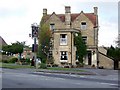
The Cross Keys, Combe Down
The Cross Keys was built in the early part of the 18th century on land that was once part of the Benedictine Priory of Bath. The first record of the Cross Keys as an inn dates from 1718.
Image: © Maigheach-gheal
Taken: 20 Sep 2009
0.12 miles
3
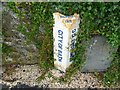
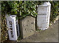
Old Boundary Marker on Southstoke Road, Combe Down
County Boundary Marker against a stone wall on the East side of Southstoke Road 5 metres north of the junction with the B3110 Midford Road. Just North of SO_WID04pb Image in the parish of Southstoke (Bath and North East Somerset District).
Inscription reads:-
: CITY.OF.BATH : : BOUNDARY / 1912 : : SOMERSET C C :
Three Boundary Markers are Grade II listed as a group.
List Entry Number: 1395000 https://historicengland.org.uk/listing/the-list/list-entry/1395000
Surveyed
Milestone Society National ID: SO_SSBA01cb
Image: © M Faherty
Taken: 18 Jul 2011
0.12 miles
4
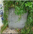
Old Boundary Marker on Southstoke Road
Parish Boundary Marker against a stone wall on the East side of Southstoke Road 5 metres North of the junction with the B3110 Midford Road. SO_SSBA01cb Image is beside it to the north and SO_BAMF01pb Image is beside it to the South. In the parish of Southstoke (Bath and North East Somerset District).
Three Boundary Markers are Grade II listed as a group.
List Entry Number: 1395000 https://historicengland.org.uk/listing/the-list/list-entry/1395000
Surveyed
Milestone Society National ID: SO_WID04pb
Image: © M Faherty
Taken: 18 Jul 2011
0.12 miles
5
Old Boundary Marker on Southstoke Road
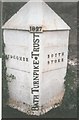
Turnpike Parish Boundary Marker - Turnpike against a stone wall on the east side of Southstoke Road 5 metres north of the junction with the B3110 Midford Road. To the south of SO_WID04pb Image In the parish of Southstoke (Bath and North East Somerset District).
Inscription reads:- WIDCOMBE and SOUTH / STOKE on its left and right faces, BATH TURNPIKE TRUST vertically on its front with 1827 above.
Three Boundary Markers are Grade II listed as a group.
List Entry Number: 1395000 https://historicengland.org.uk/listing/the-list/list-entry/1395000
Surveyed
Milestone Society National ID: SO_BAMF01pb.
Image: © J Dowding
Taken: 14 Feb 2008
0.12 miles
6
Boundary markers at the south of Bath
These group of boundary markers are testament to the many changes of boundaries over the years. The Turnpike movement brought new and better roads to the people, albeit at a price. The routes often encouraged the definition of various boundaries, be they simple parish or county status - which moved as governments thought appropriate. As it happens, these markers are on the route of a ditch dating back much further - the Wansdyke.
Image: © Neil Owen
Taken: 17 Jan 2018
0.12 miles
7
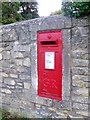
Postbox, Combe Down
A George V reign postbox beside the B3110, opposite the Cross Keys Inn.
Image: © Maigheach-gheal
Taken: 20 Sep 2009
0.12 miles
8
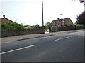
Bath ends here
These are the last houses on this side of the road. The gateposts are topped with stone chickens.
Image: © HelenK
Taken: 27 Jun 2013
0.13 miles
9
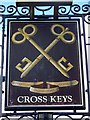
Sign for the Cross Keys
A common sign in Christian heraldry, referring to St Peter, to whom Jesus said: 'I will give unto thee the keys of the kingdom of heaven'. The papal arms show show crossed keys, and they occur again in the arms of various bishops.
Image: © Maigheach-gheal
Taken: 20 Sep 2009
0.13 miles
10
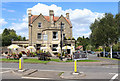
Cross Keys
Public House on the outskirts of Bath.
Image: © Wayland Smith
Taken: 19 Jul 2020
0.13 miles