IMAGES TAKEN NEAR TO
Midford Road, BATH, BA2 5RW
Introduction
This page details the photographs taken nearby to Midford Road, BA2 5RW by members of the Geograph project.
The Geograph project started in 2005 with the aim of publishing, organising and preserving representative images for every square kilometre of Great Britain, Ireland and the Isle of Man.

There are currently over 7.5m images from over14,400 individuals and you can help contribute to the project by visiting https://www.geograph.org.uk
Image Map
Images are licensed for reuse under creativecommons.org/licenses/by-sa/2.0
Notes
- Clicking on the map will re-center to the selected point.
- The higher the marker number, the further away the image location is from the centre of the postcode.
Image Listing (13 Images Found)
Images are licensed for reuse under creativecommons.org/licenses/by-sa/2.0
Image
Details
Distance
1
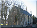
St. Martins church, Odd Down
A view looking west across the B3110 to the church of St. Martin, Odd Down.
Image: © Phil Williams
Taken: 29 Jan 2006
0.06 miles
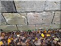
2
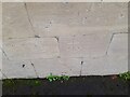
Ordnance Survey Cut Mark
This OS cut mark can be found on the NE face of St Martin's Hospital. It marks a point 162.166m above mean sea level.
Image: © Adrian Dust
Taken: 16 Nov 2022
0.08 miles
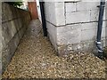
3

Entrance to St. Martin's Hospital
A community hospital for adults. Behind the hospital the Odd Down branch of Sainsbury's is taking shape and due to open at the end of the month but it is not possible to reach it by walking through the hospital grounds.
Image: © HelenK
Taken: 7 Apr 2011
0.09 miles
4
Ordnance Survey Cut Mark
This OS cut mark can be found on No513 Wellsway. It marks a point 152.577m above mean sea level.
Image: © Adrian Dust
Taken: 16 Nov 2022
0.10 miles

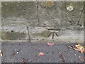
7
Ordnance Survey Cut Mark
This OS cut mark can be found on the wall SE side of Wellsway. It marks a point 158.685m above mean sea level.
Image: © Adrian Dust
Taken: 16 Nov 2022
0.11 miles
8

Ordnance Survey Cut Mark
This OS cut mark can be found on the wall NE side of Frome Road. It marks a point 164.619m above mean sea level.
Image: © Adrian Dust
Taken: 16 Nov 2022
0.13 miles
9

Ordnance Survey Rivet
This OS rivet can be found on the wall SE side of Wellsway. It marks a point 147.154m above mean sea level.
Image: © Adrian Dust
Taken: 16 Nov 2022
0.13 miles
10
Ordnance Survey Cut Mark
This OS cut mark can be found on the wall NE side of Frome Road. It marks a point 162.518m above mean sea level.
Image: © Adrian Dust
Taken: 16 Nov 2022
0.16 miles