IMAGES TAKEN NEAR TO
Old Frome Road, BATH, BA2 5RH
Introduction
This page details the photographs taken nearby to Old Frome Road, BA2 5RH by members of the Geograph project.
The Geograph project started in 2005 with the aim of publishing, organising and preserving representative images for every square kilometre of Great Britain, Ireland and the Isle of Man.

There are currently over 7.5m images from over14,400 individuals and you can help contribute to the project by visiting https://www.geograph.org.uk
Image Map
Images are licensed for reuse under creativecommons.org/licenses/by-sa/2.0
Notes
- Clicking on the map will re-center to the selected point.
- The higher the marker number, the further away the image location is from the centre of the postcode.
Image Listing (29 Images Found)
Images are licensed for reuse under creativecommons.org/licenses/by-sa/2.0
Image
Details
Distance
1

The Wansdyke near Bath
As straight as a Roman road for much of the time here. the old ditch is largely undetectable after centuries of walking and farming.
Image: © Neil Owen
Taken: 17 Jan 2018
0.08 miles
2
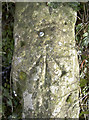
Rivet benchmark on the Wansdyke
A rivet benchmark, as listed in the Benchmark Database: http://www.bench-marks.org.uk/bm92083 , remains on a small stone wall on the Wansdyke path on Bath's southern downland. It is on a junction of paths and close to the Three Ways School. The latter is a modern (2007) school for special needs pupils. Before that there were a number of individual establishments, and the original school was founded in the early twentieth century as Three Ways Cottages; this was a part of the nearby Poor Law Workhouse and a Bath Corporation institution.
See Image] for a wider view.
Image: © Neil Owen
Taken: 17 Jan 2018
0.10 miles
3
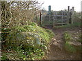
Three ways at Three Ways
A footpath junction along the Wansdyke, close to Three Ways school. A post WWII benchmark lies on the stone wall - see Image
Image: © Neil Owen
Taken: 17 Jan 2018
0.10 miles
4
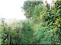
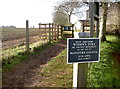
Footpath, Combe Down
The enclosed footpath uses part of the Wansdyke.
Image: © Maigheach-gheal
Taken: 20 Sep 2009
0.12 miles
5
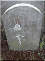
Boundary stone on Midford Road
Dating back to the 1890s and probably when the old lines of the city of Bath and the county of Somerset were here; they have moved on since. See Image] for a wider view.
Image: © Neil Owen
Taken: 17 Jan 2018
0.16 miles
6

Marker on Midford Road
Close to the old Wansdyke is a collection of boundaries - one stone here marks part of the feature. See Image
Image: © Neil Owen
Taken: 17 Jan 2018
0.16 miles
7

Ancient path and manor estate
The Wansdyke runs straight along this line, although little of the original ditch and works are evident now. To the left is the large expanse of the Manor Farm estate, which includes farmland and modern tree plantations.
Image: © Neil Owen
Taken: 17 Jan 2018
0.16 miles
8

Old Boundary Marker by the B3110, Midford Road, Bath
Parish Boundary Marker on the south side of the B3110 Midford Road, next to a bus shelter west of the junction with Southstoke Road. Partly hidden by a black waste bin since 2014. On the boundary of Southstoke parish (Bath And North East Somerset District) and Bath. L and W represents Lyncombe with Widcombe parish, absorbed into Bath parish in 1900. See also https://www.geograph.org.uk/photo/5654908 and https://www.geograph.org.uk/photo/5654910.
Surveyed
Milestone Society National ID: SO_WID03pb.
Image: © M Faherty
Taken: 18 Jul 2011
0.17 miles
9
Woden's way near Bath
The Wansdyke runs through many miles of countryside in the south of England. Its construction ranges across the lengths but parts appear to be late or post Roman at the earliest, and the techniques used seem in a more Roman military style.
This section is a noticeably linear ditch that runs along the southern extremes of the old Roman town of Bath. Further ahead, the dyke crosses the old Fosse Way.
Image: © Neil Owen
Taken: 17 Jan 2018
0.17 miles
10

2008 : The Cross Keys
Where South Stoke Road crosses the B3110 at Combe Down.
Image: © Maurice Pullin
Taken: 14 Apr 2008
0.17 miles