IMAGES TAKEN NEAR TO
Beechwood Road, BATH, BA2 5JT
Introduction
This page details the photographs taken nearby to Beechwood Road, BA2 5JT by members of the Geograph project.
The Geograph project started in 2005 with the aim of publishing, organising and preserving representative images for every square kilometre of Great Britain, Ireland and the Isle of Man.

There are currently over 7.5m images from over14,400 individuals and you can help contribute to the project by visiting https://www.geograph.org.uk
Image Map
Images are licensed for reuse under creativecommons.org/licenses/by-sa/2.0
Notes
- Clicking on the map will re-center to the selected point.
- The higher the marker number, the further away the image location is from the centre of the postcode.
Image Listing (13 Images Found)
Images are licensed for reuse under creativecommons.org/licenses/by-sa/2.0
Image
Details
Distance
1

Old Boundary Marker in Beech Wood
Parish Boundary Marker beside a public footpath in the north part of Beech Wood, south of Beechwood Road, Combe Down. In 1894 this marked the boundary of Lyncombe and Widcombe and Monkton Combe parishes. From 1900 if was the boundary of Bath and Monkton Combe parishes. From 1967 it was entirely in Bath parish which was then abolished in 1974.
Milestone Society National ID: SO_WID11pb
Image: © A Ward
Taken: 22 Nov 2021
0.13 miles
2

King William IV Pub, Combe Down
Dating from about 1830 https://www.historicengland.org.uk/listing/the-list/list-entry/1394730 , this is at the corner of Rock Hall Lane (centre) and Combe Road.
Image: © Derek Harper
Taken: 23 Feb 2016
0.15 miles
3

Direction Sign ? Signpost on Combe Road, Combe Down
Located in Combe Down, Bath, on the east side of the Y junction of Combe Road and Rock Hall Lane. 2 arms and pyramid finial.
Milestone Society National ID: SO_ST7562
Image: © E Prideaux
Taken: Unknown
0.16 miles
4

Direction Sign – Signpost on Combe Road, Combe Down
Located in Combe Down, Bath, on the east side of the Y junction of Combe Road and Rock Hall Lane. 2 arms and pyramid finial. See also https://www.geograph.org.uk/photo/6744301: building work has now been completed.
Milestone Society National ID: SO_ST7562
Image: © R Raynsford
Taken: 1 Jan 2020
0.16 miles
5

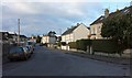
Bath : Church Road
Looking along Church Road from the junction with Summer Lane.
Image: © Lewis Clarke
Taken: 6 Aug 2020
0.18 miles
6
Church Road, Combe Down
The row of five houses in the centre, Church Place, is a fairly recent arrival. To its left, down the road, is the Post Office https://www.historicengland.org.uk/listing/the-list/list-entry/1394964 which has apparently reopened recently after refurbishment.
Image: © Derek Harper
Taken: 23 Feb 2016
0.19 miles
7
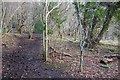
Path through Beech Wood
Footpath BA16/3 climbs up the edge of the wood towards Combe Down. Or is it footpath BC52/7? The fact that it follows a parish boundary is perhaps why it seems to have two numbers.
Image: © Derek Harper
Taken: 23 Feb 2016
0.19 miles
8
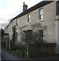
Listed buildings, Combe Down
Bearer is 24, Combe Road https://www.historicengland.org.uk/listing/the-list/list-entry/1394950 ; beyond is a row of three "artisanal houses, probably related to the quarrying industry for which Combe Down was celebrated at this time" https://www.historicengland.org.uk/listing/the-list/list-entry/1394952 .
Image: © Derek Harper
Taken: 23 Feb 2016
0.19 miles
9
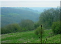
2008 : Bottom end of Horsecombe Vale
A pleasant little valley, well worth the effort of a walk along the bottom beside the little stream.
Image: © Maurice Pullin
Taken: 27 Apr 2008
0.21 miles
10
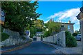
Bath : Belmont Road
A road seen off Summer Lane.
Image: © Lewis Clarke
Taken: 6 Aug 2020
0.22 miles