IMAGES TAKEN NEAR TO
The Avenue, BATH, BA2 5EQ
Introduction
This page details the photographs taken nearby to The Avenue, BA2 5EQ by members of the Geograph project.
The Geograph project started in 2005 with the aim of publishing, organising and preserving representative images for every square kilometre of Great Britain, Ireland and the Isle of Man.

There are currently over 7.5m images from over14,400 individuals and you can help contribute to the project by visiting https://www.geograph.org.uk
Image Map
Images are licensed for reuse under creativecommons.org/licenses/by-sa/2.0
Notes
- Clicking on the map will re-center to the selected point.
- The higher the marker number, the further away the image location is from the centre of the postcode.
Image Listing (48 Images Found)
Images are licensed for reuse under creativecommons.org/licenses/by-sa/2.0
Image
Details
Distance
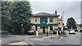
2
The Hadley Arms, Combe Down
Apparently it is good for skittles.
Image: © Bill Boaden
Taken: 29 Jul 2016
0.05 miles
3
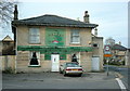
2008 : The Hadley Arms, Combe Down
Or should that be Arm, a friend of Nelson perhaps? http://www.imagesofengland.org.uk/details/default.aspx?id=446806
Image: © Maurice Pullin
Taken: 27 Apr 2008
0.05 miles
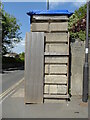
4
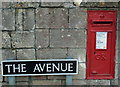
2008 : George V Post Box
At Combe Down.
George VI post boxes were marked G VI R.
Image: © Maurice Pullin
Taken: 27 Apr 2008
0.06 miles
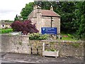
5
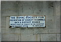
2008 : R.S.P.C.A. advertisement
At the junction of The Avenue and North Road. Possibly dating from the 1920's or 30's.
Image: © Maurice Pullin
Taken: 27 Apr 2008
0.06 miles
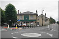
7

Firs Quarry
This is a photo of the main passage in Firs quarry. Quarrying on Combe Down started around the 1600's but became famous when Ralph Allen took over the quarries and built Prior Park (1740) as a showpiece. All the underground quarries here are being filled with concrete and a major part of Bath's history will be lost forever.
Image: © Derek Hawkins
Taken: Unknown
0.06 miles
8
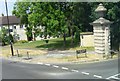
Combe Down, horse trough
On North Road, erected to commemorate the coronation of King George V on June 22nd 1911.
Image: © Mike Faherty
Taken: 18 Jul 2011
0.07 miles
9
Old Boundary Marker on the A3062 Ralph Allen Drive in Bath
Parish Boundary Marker inscribed in the south face of a massive stone gatepost on the northeast side of the junction of the A3062 Ralph Allen Drive and North Road in Bath. Inscribed L W P. On the former boundary of Lyncombe and Widcombe and Monkton Combe parishes, but now Bath and Monkton Combe. Grade II Listed details https://historicengland.org.uk/listing/the-list/list-entry/1394607.
Milestone Society National ID: SO_WID08pb
Image: © Roadside Relics
Taken: 16 May 2023
0.07 miles
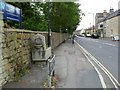
10
Drinking trough, North Road
The trough commemorates the coronation of King George V in 1911.
The building behind is the Top Lodge at Prior Park.
Image: © Rose and Trev Clough
Taken: 10 Jul 2012
0.07 miles