IMAGES TAKEN NEAR TO
Albert Place, BATH, BA2 5EP
Introduction
This page details the photographs taken nearby to Albert Place, BA2 5EP by members of the Geograph project.
The Geograph project started in 2005 with the aim of publishing, organising and preserving representative images for every square kilometre of Great Britain, Ireland and the Isle of Man.

There are currently over 7.5m images from over14,400 individuals and you can help contribute to the project by visiting https://www.geograph.org.uk
Image Map
Images are licensed for reuse under creativecommons.org/licenses/by-sa/2.0
Notes
- Clicking on the map will re-center to the selected point.
- The higher the marker number, the further away the image location is from the centre of the postcode.
Image Listing (30 Images Found)
Images are licensed for reuse under creativecommons.org/licenses/by-sa/2.0
Image
Details
Distance
1
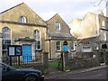
Union Chapel, Combe Down
Bath at one time had a multitude of nonconformist chapels, many of which were competing to try to win wealthy and influential converts. This one, however, was founded in 1815 as a place of worship for workers in the nearby stone mines and their families.
Image: © HelenK
Taken: 3 Feb 2011
0.07 miles
2
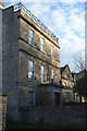
Claremont House, Combe Down
"This is {the} first of series of villas continued along north side of Church Road, with fine views over countryside to south" https://www.historicengland.org.uk/listing/the-list/list-entry/1395684 .
Image: © Derek Harper
Taken: 23 Feb 2016
0.11 miles
3

Bath : Church Road
Looking along Church Road in the Combe Down area of Bath.
Image: © Lewis Clarke
Taken: 6 Aug 2020
0.11 miles
4
Holy Trinity Church, Combe Down
A view from Church Road of the C10 church described at https://www.historicengland.org.uk/listing/the-list/list-entry/1394011 .
Image: © Derek Harper
Taken: 23 Feb 2016
0.13 miles
5

Listed buildings, Combe Down
On Belmont Road. The prominent house is a "large detached Italianate villa ... One of group of four similar villas exploiting sloping sites with extensive views to south" https://www.historicengland.org.uk/listing/the-list/list-entry/1394530 .
Image: © Derek Harper
Taken: 23 Feb 2016
0.14 miles
6
Holy Trinity Church, Combe Down
Image: © Derek Harper
Taken: 23 Feb 2016
0.14 miles
7
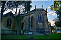
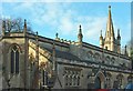
Bath : Holy Trinity Church
Anglican parish church. Dated 1834 (1832-1835) and 1883-1884. The church was built through the endeavours of George Steart, paper manufacturer, of Bally, Ellen & Steart, proprietors of the De Montalt Mill.
Image: © Lewis Clarke
Taken: 6 Aug 2020
0.14 miles
8
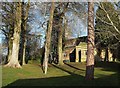
Churchyard, Combe Down
Of Holy Trinity Church. Beyond the churchyard and a path below its level is Vale View House, a "handsome villa in commanding position on a bend in the road" https://www.historicengland.org.uk/listing/the-list/list-entry/1394532 .
Image: © Derek Harper
Taken: 23 Feb 2016
0.14 miles
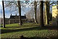
9
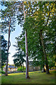
Bath : Holy Trinity Church Grounds
Trees in the grounds of the church.
Image: © Lewis Clarke
Taken: 6 Aug 2020
0.14 miles
10
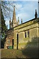
Holy Trinity Church, Combe Down
The church is a little obscured by the well-treed, not to say wooded, churchyard. It is C19 "early Gothic Revival in what Pevsner calls `fanciful and crazy', but the major additions in serious C14 Decorated detail" https://www.historicengland.org.uk/listing/the-list/list-entry/1394011 .
Image: © Derek Harper
Taken: 23 Feb 2016
0.14 miles