IMAGES TAKEN NEAR TO
Chaucer Road, BATH, BA2 4SL
Introduction
This page details the photographs taken nearby to Chaucer Road, BA2 4SL by members of the Geograph project.
The Geograph project started in 2005 with the aim of publishing, organising and preserving representative images for every square kilometre of Great Britain, Ireland and the Isle of Man.

There are currently over 7.5m images from over14,400 individuals and you can help contribute to the project by visiting https://www.geograph.org.uk
Image Map
Images are licensed for reuse under creativecommons.org/licenses/by-sa/2.0
Notes
- Clicking on the map will re-center to the selected point.
- The higher the marker number, the further away the image location is from the centre of the postcode.
Image Listing (75 Images Found)
Images are licensed for reuse under creativecommons.org/licenses/by-sa/2.0
Image
Details
Distance
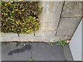
1
Ordnance Survey Cut Mark
This OS cut mark can be found on No25 Milton Avenue. It marks a point 92.289m above mean sea level.
Image: © Adrian Dust
Taken: 2 Dec 2022
0.02 miles

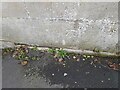
3
Ordnance Survey Cut Mark
This OS cut mark can be found on the wall of No12 Chaucer Road. It marks a point 92.797m above mean sea level.
Image: © Adrian Dust
Taken: 2 Dec 2022
0.07 miles
4
North side of Devonshire Buildings, Bath
These houses were built around 1904 - a century after houses the other side of the road.
Image: © David Hawgood
Taken: 2 Jun 2009
0.08 miles
5

South side of Devonshire Buildings, Bath
These houses were built in the first few years of the 19th Century.
Image: © David Hawgood
Taken: 2 Jun 2009
0.09 miles
6
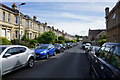
Chaucer Road, Bear Flat
A mature residential street in Bath. All the local roads are named after classic English writers.
Image: © Bill Boaden
Taken: 29 Jul 2016
0.09 miles
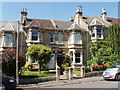
7

Houses on Chaucer Road, Bath
Canted stone bays with neat decorations make an impressive terrace. Taken from the junction with Shakespeare Avenue.
Image: © Derek Harper
Taken: 25 Aug 2008
0.11 miles
8

Ordnance Survey Cut Mark
This OS cut mark can be found on the wall of No45 Shakespear Avenue. It marks a point 91.842m above mean sea level.
Image: © Adrian Dust
Taken: 2 Dec 2022
0.12 miles
9
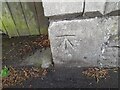
Ordnance Survey Cut Mark
This OS cut mark can be found on the gatepost of No 9 Devonshire Buildings. It marks a point 90.077m above mean sea level.
Image: © Adrian Dust
Taken: 16 Nov 2022
0.12 miles
10
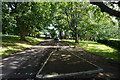
Ring road in Alexandra Park
The road loops right round the park, giving an opportunity for parking along it. Much of the park is pleasantly shady.
Image: © Bill Boaden
Taken: 29 Jul 2016
0.13 miles