IMAGES TAKEN NEAR TO
Wellsway, BATH, BA2 4SE
Introduction
This page details the photographs taken nearby to Wellsway, BA2 4SE by members of the Geograph project.
The Geograph project started in 2005 with the aim of publishing, organising and preserving representative images for every square kilometre of Great Britain, Ireland and the Isle of Man.

There are currently over 7.5m images from over14,400 individuals and you can help contribute to the project by visiting https://www.geograph.org.uk
Image Map
Images are licensed for reuse under creativecommons.org/licenses/by-sa/2.0
Notes
- Clicking on the map will re-center to the selected point.
- The higher the marker number, the further away the image location is from the centre of the postcode.
Image Listing (14 Images Found)
Images are licensed for reuse under creativecommons.org/licenses/by-sa/2.0
Image
Details
Distance
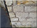
1
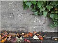
Ordnance Survey Cut Mark
This OS cut mark can be found on the wall of No144 Wellsway. It marks a point 128.167m above mean sea level.
Image: © Adrian Dust
Taken: 16 Nov 2022
0.02 miles
2
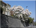
Magnolia, in full bloom, Wells Way, Bath
Image: © Roger Cornfoot
Taken: 23 Apr 2010
0.04 miles
4
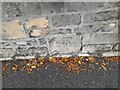
Ordnance Survey Cut Mark
This OS cut mark can be found on the wall of No174 Wellsway. It marks a point 138.429m above mean sea level.
Image: © Adrian Dust
Taken: 16 Nov 2022
0.11 miles
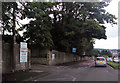
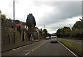
6
Entry Hill
Residential street in Bath.
Image: © Wayland Smith
Taken: 19 Jul 2020
0.15 miles
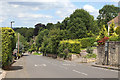
7

Bath : Odd Down - Entry Hill
Looking along Entry Hill.
Image: © Lewis Clarke
Taken: 11 Jul 2023
0.16 miles
8
Ordnance Survey Cut Mark
This OS cut mark can be found on the wall of No204 Bloomfield Road. It marks a point 115.348m above mean sea level.
Image: © Adrian Dust
Taken: 16 Nov 2022
0.21 miles
9

Old Milestone by Entry Hill, Bath parish
Stone post (plate lost) by the UC road, in parish of BATH (BATH AND NORTH EAST SOMERSET District), Entry Hill, near junction with Entry Hill Drive, on pavement against stone wall, on East side of road. Bath Guildhall iron plate, erected by the Bath turnpike trust in the 18th century.
Inscription reads:-
BATH
1
Milestone Society National ID: SO_BAWL01.
Image: © JR Dowding
Taken: 14 Feb 2008
0.21 miles
10

Ordnance Survey Rivet
This OS rivet can be found on the wall SE side of Wellsway. It marks a point 147.154m above mean sea level.
Image: © Adrian Dust
Taken: 16 Nov 2022
0.23 miles