IMAGES TAKEN NEAR TO
Wellsway, BATH, BA2 4RU
Introduction
This page details the photographs taken nearby to Wellsway, BA2 4RU by members of the Geograph project.
The Geograph project started in 2005 with the aim of publishing, organising and preserving representative images for every square kilometre of Great Britain, Ireland and the Isle of Man.

There are currently over 7.5m images from over14,400 individuals and you can help contribute to the project by visiting https://www.geograph.org.uk
Image Map
Images are licensed for reuse under creativecommons.org/licenses/by-sa/2.0
Notes
- Clicking on the map will re-center to the selected point.
- The higher the marker number, the further away the image location is from the centre of the postcode.
Image Listing (70 Images Found)
Images are licensed for reuse under creativecommons.org/licenses/by-sa/2.0
Image
Details
Distance
1
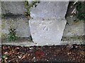
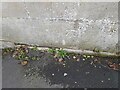
Ordnance Survey Cut Mark
This OS cut mark can be found on the wall between Nos 3 & 5 Bloomfield Road. It marks a point 74.341m above mean sea level.
Image: © Adrian Dust
Taken: 16 Nov 2022
0.04 miles
2
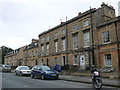
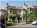
Georgian Houses Bloomfield Rd.
These are three storey terraced houses of Bath stone whose gardens back on to the local allotment gardens. The trees on the far left are on the small park known as Bear Flat.
Image: © Nigel Mykura
Taken: 30 Sep 2012
0.06 miles
3

Ordnance Survey Cut Mark
This OS cut mark can be found on the gatepost of No19 Bloomfield Road. It marks a point 76.313m above mean sea level.
Image: © Adrian Dust
Taken: 16 Nov 2022
0.07 miles
4
2008 : Wellsway at the junction with Bloomfield Road
About 200 yards south of Image] Bloomfield Road leaves Wellsway to the right. Anyone walking or cycling this way would be well advised to take this as an alternative route to Odd Down, it is safer, more interesting and adds very little distance.
Image: © Maurice Pullin
Taken: 24 Jul 2008
0.07 miles
5

Junction of Bloomfield road and the A367 at Bear Flat
Image: © John Firth
Taken: 4 Sep 2017
0.08 miles
6
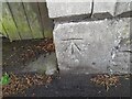
Ordnance Survey Cut Mark
This OS cut mark can be found on the gatepost of No 9 Devonshire Buildings. It marks a point 90.077m above mean sea level.
Image: © Adrian Dust
Taken: 16 Nov 2022
0.09 miles
7
North side of Devonshire Buildings, Bath
These houses were built around 1904 - a century after houses the other side of the road.
Image: © David Hawgood
Taken: 2 Jun 2009
0.10 miles
8
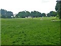
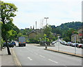
Bear Flat
The recreation area has the wonderful name of Bear Flat.
Image: © Michael Dibb
Taken: 2 Jun 2018
0.10 miles
9
Ordnance Survey Cut Mark
This OS cut mark can be found on No25 Milton Avenue. It marks a point 92.289m above mean sea level.
Image: © Adrian Dust
Taken: 2 Dec 2022
0.11 miles
10

South side of Devonshire Buildings, Bath
These houses were built in the first few years of the 19th Century.
Image: © David Hawgood
Taken: 2 Jun 2009
0.12 miles