IMAGES TAKEN NEAR TO
Magdalen Road, BATH, BA2 4QA
Introduction
This page details the photographs taken nearby to Magdalen Road, BA2 4QA by members of the Geograph project.
The Geograph project started in 2005 with the aim of publishing, organising and preserving representative images for every square kilometre of Great Britain, Ireland and the Isle of Man.

There are currently over 7.5m images from over14,400 individuals and you can help contribute to the project by visiting https://www.geograph.org.uk
Image Map
Images are licensed for reuse under creativecommons.org/licenses/by-sa/2.0
Notes
- Clicking on the map will re-center to the selected point.
- The higher the marker number, the further away the image location is from the centre of the postcode.
Image Listing (137 Images Found)
Images are licensed for reuse under creativecommons.org/licenses/by-sa/2.0
Image
Details
Distance
1
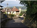
Holloway, Bath
With a raised pavement on the left and the woods of Beechen Cliff on the right, the Fosse Way drops from Bear Flat towards the city, past St Mary Magdalen's Chapel, which is the chapel of a leper hospital founded in 1495.
Image: © Derek Harper
Taken: 25 Aug 2008
0.01 miles
2
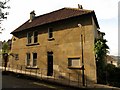
House on Holloway, Bath
This Bath stone house also appears in Image and is at the corner of Magdalen Road, where the raised pavement ends. Holloway (a "fair street", according to Leland) is on the line of the Roman Fosse Way as it submits to the needs of geography and curves down into Bath.
Image: © Derek Harper
Taken: 25 Aug 2008
0.01 miles
3

St Mary Magdalen's Chapel, Bath
The church also appears in Image, and is the chapel of a leper hospital rebuilt by Prior John Cantlow in 1495, after it was united with Bath Priory.
On the left is Magdalen Road. To the right, Holloway descends towards the city centre.
Image: © Derek Harper
Taken: 25 Aug 2008
0.02 miles
4
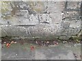
Ordnance Survey Cut Mark
This OS cut mark can be found on the porch of the chapel on Holloway. It marks a point 57.056m above mean sea level.
Image: © Adrian Dust
Taken: 2 Dec 2022
0.03 miles
6
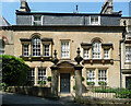
Paradise House, Holloway, Bath
Attractive if rather too busy Palladian front. Good gatepiers too. Built c1760. Grade II listed.
It was a hotel, but it appears to have gone out of business since this photo.
Image: © Stephen Richards
Taken: 20 Jun 2017
0.05 miles

8

Houses on Beechen Cliff
These houses front onto Beechen Cliff Road; their rear overlooks this path. Trees block much of the view from this part of the hill.
Image: © Derek Harper
Taken: 25 Aug 2008
0.07 miles
9

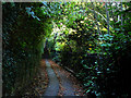
Path near the viewpoint on Beechen Cliff
Image: © Chris Gunns
Taken: 20 Oct 2007
0.07 miles
10
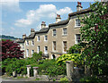
St Mary's Buildings, Wells Road, Bath
A fine terrace featuring one of the trademarks of Bath's better Georgian builders, the ramped cornice to smooth the transition up/down the slope. By John Pinch the Elder, c1820. Grade II listed.
Image: © Stephen Richards
Taken: 20 Jun 2017
0.07 miles