IMAGES TAKEN NEAR TO
Forefield Terrace, BATH, BA2 4PD
Introduction
This page details the photographs taken nearby to Forefield Terrace, BA2 4PD by members of the Geograph project.
The Geograph project started in 2005 with the aim of publishing, organising and preserving representative images for every square kilometre of Great Britain, Ireland and the Isle of Man.

There are currently over 7.5m images from over14,400 individuals and you can help contribute to the project by visiting https://www.geograph.org.uk
Image Map
Images are licensed for reuse under creativecommons.org/licenses/by-sa/2.0
Notes
- Clicking on the map will re-center to the selected point.
- The higher the marker number, the further away the image location is from the centre of the postcode.
Image Listing (256 Images Found)
Images are licensed for reuse under creativecommons.org/licenses/by-sa/2.0
Image
Details
Distance
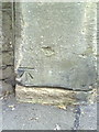
1
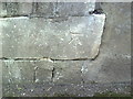
Benchmark on wall of Forefield Rise
Ordnance Survey cut mark benchmark described on the Bench Mark Database at http://www.bench-marks.org.uk/bm35398.
Image: © Roger Templeman
Taken: 3 Sep 2010
0.02 miles
2
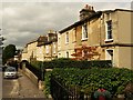
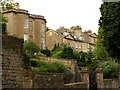
Lyncombe Hill, Bath
A pleasant road of stone houses that drops increasingly steeply as it crosses a gridline towards the River Avon. Forefield Rise is the path on the immediate right.
Image: © Derek Harper
Taken: 25 Aug 2008
0.03 miles
3
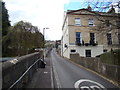
View up Forefield Rise from Prior Park Road
Looking south-southwest.
Image: © Robert Lamb
Taken: 15 Apr 2012
0.03 miles
4
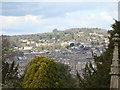
View of the city centre from Abbey Cemetery
Looking north-northwest. The Abbey can be seen in the foreground.
Image: © Robert Lamb
Taken: 15 Apr 2012
0.04 miles
5
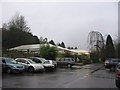
Prior Park Garden and Pet Centre
A garden centre and seller of pet supplies conveniently situated not too far from the city centre, on Prior Park Rd. Outdoor plants are behind the fence on the left.
Image: © HelenK
Taken: 10 Feb 2011
0.06 miles
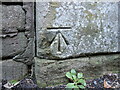
6
Benchmark on gatepost on #33 Prior Park Road
Ordnance Survey cut mark benchmark described on the Bench Mark Database at http://www.bench-marks.org.uk/bm35414.
Image: © Roger Templeman
Taken: 3 Sep 2010
0.07 miles
7
Benchmark on Prior Park Road
One of several on the lengthy suburban road in Bath. See https://www.bench-marks.org.uk/bm35414 for the entry in the Benchmark Database and Image] for a wider view.
Image: © Neil Owen
Taken: 10 Jan 2024
0.07 miles
8
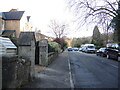
Prior Park Road, just up from the junction with Gordon Road
The road extends a long way up the hill. On the nearest pier is a benchmark - see Image
Image: © Neil Owen
Taken: 10 Jan 2024
0.07 miles
9
Houses overlooking Lyncombe Hill
Bath stone houses on the steep hill to the south of the Avon.
Image: © Derek Harper
Taken: 25 Aug 2008
0.07 miles
10
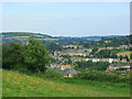
2008 : North east from Lyncombe Hill, Bath
Turning anticlockwise from Image] the view is now over Bathwick with Little Solsbury Hill Image to the left and the slope at the bottom of Bathampton Down to the right.
Further on between the two we have Banner Down.
Image: © Maurice Pullin
Taken: 24 Jul 2008
0.07 miles