IMAGES TAKEN NEAR TO
Clarendon Road, BATH, BA2 4NJ
Introduction
This page details the photographs taken nearby to Clarendon Road, BA2 4NJ by members of the Geograph project.
The Geograph project started in 2005 with the aim of publishing, organising and preserving representative images for every square kilometre of Great Britain, Ireland and the Isle of Man.

There are currently over 7.5m images from over14,400 individuals and you can help contribute to the project by visiting https://www.geograph.org.uk
Image Map
Images are licensed for reuse under creativecommons.org/licenses/by-sa/2.0
Notes
- Clicking on the map will re-center to the selected point.
- The higher the marker number, the further away the image location is from the centre of the postcode.
Image Listing (218 Images Found)
Images are licensed for reuse under creativecommons.org/licenses/by-sa/2.0
Image
Details
Distance
1
View of the curvy terrace on Widcombe Crescent from Prior Park Road
Looking north-northeast.
Image: © Robert Lamb
Taken: 15 Apr 2012
0.02 miles
2
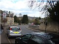
View down the hill on Prior Park Road
Looking north-northwest as the road winds its way down the hill to the city centre.
Image: © Robert Lamb
Taken: 15 Apr 2012
0.02 miles
3
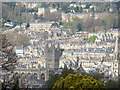
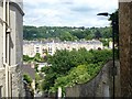
View of the city centre from Abbey Cemetery #2
Looking north-northwest.
Image: © Robert Lamb
Taken: 15 Apr 2012
0.03 miles
4
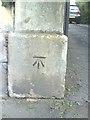
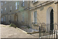
Benchmark on gatepost of #47 Prior Park Road
Ordnance Survey cut mark benchmark described on the Bench Mark Database at http://www.bench-marks.org.uk/bm35413.
Image: © Roger Templeman
Taken: 3 Sep 2010
0.04 miles
5
Widcombe Crescent, Widcombe
An attractive crescent of 14 houses built c1805 off Widcombe Hill.
Image: © Stephen McKay
Taken: 20 Sep 2008
0.04 miles
6
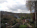
View of the hills from Clarendon Terrace
Looking south-southwest.
Image: © Robert Lamb
Taken: 15 Apr 2012
0.04 miles
7
View of Royal Crescent from Abbey Cemetery
About the only way you can get the entire terrace in shot (except if you have a fish-eye or wide angle lens)! Looking north-northeast.
Image: © Robert Lamb
Taken: 15 Apr 2012
0.04 miles
8
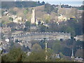
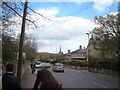
View of houses on the hills from Prior Park Road
Looking north-northwest. The church is St Matthew's on Widcombe Hill. See Image for a closer view of this.
Image: © Robert Lamb
Taken: 15 Apr 2012
0.04 miles
9
View down Prior Park Road
Looking north-northwest towards the city centre.
Image: © Robert Lamb
Taken: 15 Apr 2012
0.05 miles
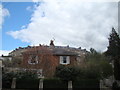
10
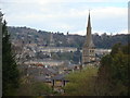
The view from Lyncombe Hill
Looking east, the backs of the houses in view are in Clarendon Road.
Image: © Michael Dibb
Taken: 2 Jun 2018
0.05 miles