IMAGES TAKEN NEAR TO
Greenway Lane, BATH, BA2 4LW
Introduction
This page details the photographs taken nearby to Greenway Lane, BA2 4LW by members of the Geograph project.
The Geograph project started in 2005 with the aim of publishing, organising and preserving representative images for every square kilometre of Great Britain, Ireland and the Isle of Man.

There are currently over 7.5m images from over14,400 individuals and you can help contribute to the project by visiting https://www.geograph.org.uk
Image Map
Images are licensed for reuse under creativecommons.org/licenses/by-sa/2.0
Notes
- Clicking on the map will re-center to the selected point.
- The higher the marker number, the further away the image location is from the centre of the postcode.
Image Listing (51 Images Found)
Images are licensed for reuse under creativecommons.org/licenses/by-sa/2.0
Image
Details
Distance
1
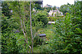
Bath : Lyncombe Vale Allotments
Looking towards a grassy hill with allotments on it.
Image: © Lewis Clarke
Taken: 6 Aug 2020
0.04 miles
2
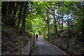
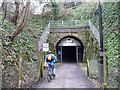
Bath : Two Tunnels Greenway
The path emerges from Devonshire Tunnel.
Image: © Lewis Clarke
Taken: 6 Aug 2020
0.04 miles
3
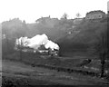
The Somerset & Dorset Railway in Lyncombe Vale
BR Standard 4 80043 (built 7/52 Brighton, withdrawn 3/66) heads the 3.20pm from Bath Green Park to Templecombe out of Devonshire Tunnel into Lyncombe Vale. In about ¼ mile, climbing at 1 in 50, it will reach the summit of the climb out of Bath & drop down through Coombe Down Tunnel to Midford. This train was notable - the very last daytime service train to leave Green Park; needless to say it was packed & I was one of a large crowd of photographers.
Image: © Martin Tester
Taken: 5 Mar 1966
0.06 miles
4
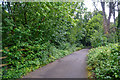
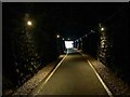
Bath : Two Tunnels Greenway
A footpath heading out from Bath.
Image: © Lewis Clarke
Taken: 6 Aug 2020
0.06 miles
5

South side of Devonshire Buildings, Bath
These houses were built in the first few years of the 19th Century.
Image: © David Hawgood
Taken: 2 Jun 2009
0.07 miles
6
![Denonshire Tunnel [4]](https://s0.geograph.org.uk/geophotos/05/81/26/5812620_64e39f50_120x120.jpg)
Denonshire Tunnel [4]
An information board alongside the Two Tunnels Greenway.
The Greenway is the former trackbed of the Somerset & Dorset Joint Railway which ran from Bath to Bournemouth. The heavily engineered railway closed in 1966. Part of the trackbed became a linear park whilst further south it was used as an informal footpath. A campaign to re-open the route as a shared-use path started in 2005 and the Two Tunnels Greenway opened in April, 2013.
Image: © Michael Dibb
Taken: 2 Jun 2018
0.07 miles
7

Lyncombe Vale North Allotments
Seen from the track.
Image: © Michael Dibb
Taken: 2 Jun 2018
0.07 miles
8
Cyclist entering Devonshire Tunnel from the east
Part of the Two Tunnels Greenway. This was once the Somerset and Dorset Joint Railway, closed in 1966 and re-opened as a linear park and path in 2013.
Image: © Christine Johnstone
Taken: 1 Apr 2018
0.07 miles
9
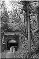
Bath : Devonshire Tunnel
Devonshire Tunnel is on the closed Somerset & Dorset Joint Railway main line, between Midford and Bath Green Park railway stations, below high ground and the southern suburbs of Bath emerging below the northern slopes of Combe Down village. It opened in 1874 and was named after the road called Devonshire Buildings which lie immediately above the tunnel.
It now forms one of the eponymous tunnels in the Two Tunnels Greenway.
Image: © Lewis Clarke
Taken: 6 Aug 2020
0.08 miles
10
Devonshire Tunnel's eastern portal
The eastern portal of Devonshire Tunnel, which formerly took the Somerset & Dorset Railway beneath the southern edge of Bath. After many years blocked up - the Western portal was completely buried when the approach cutting was filled in in 1973 - the tunnel has recently been reopened as part of the Two Tunnels Greenway, a footpath and cycleway to Midford along the route of the old S&D. It's interesting to note that the telegraph pole on the right has survived all the changes ... I have a picture in Mac Hawkins' excellent "Somerset & Dorset: Then and Now" book which shows this very telegraph pole in 1958, when the railway was still open.
Image: © John Winder
Taken: 10 Nov 2016
0.08 miles