IMAGES TAKEN NEAR TO
Rennie Close, BATH, BA2 4GZ
Introduction
This page details the photographs taken nearby to Rennie Close, BA2 4GZ by members of the Geograph project.
The Geograph project started in 2005 with the aim of publishing, organising and preserving representative images for every square kilometre of Great Britain, Ireland and the Isle of Man.

There are currently over 7.5m images from over14,400 individuals and you can help contribute to the project by visiting https://www.geograph.org.uk
Image Map
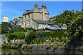
Images are licensed for reuse under creativecommons.org/licenses/by-sa/2.0
Notes
- Clicking on the map will re-center to the selected point.
- The higher the marker number, the further away the image location is from the centre of the postcode.
Image Listing (305 Images Found)
Images are licensed for reuse under creativecommons.org/licenses/by-sa/2.0
Image
Details
Distance
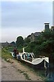
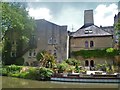
2
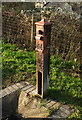
Water point, Kennet and Avon Canal
I believe this is water point L2.
Image: © Derek Harper
Taken: 8 Dec 2019
0.04 miles
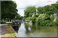
3
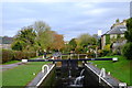
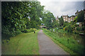
Top lock, Kennet & Avon Canal
Taken from the same spot as Image, but looking the other way, towards Bathwick. This is one of a total of 105 locks on the whole 87 miles of mixed canal and navigable river which make up the K&A.
The K&A is made up of two stretches of navigable river linked by a canal which was constructed in the late 18th and early 19th Centuries. As usual, the navigation fell into disuse when the Victorians discovered railways, and became more or less derelict by the early 20th Century. It was restored, largely by volunteers, and finally reopened completely in 1990.
Image: © John Winder
Taken: 9 Nov 2016
0.04 miles
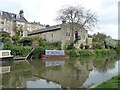
4
The ?Charlotte Dundas? at Widcombe Top Lock, 1966
1966 was a time when the drive to reopen the Kennet and Avon Canal was in its early years.
The 'Charlotte Dundas' was the first craft to offer trips, initially over a short stretch from Widcombe Top Lock in Bath. It was a purpose built paddle-wheel craft, diesel powered with hydraulic drive. This layout enabled it to travel in either direction, the rudder being moved from one end to the other, as there was no facility to turn the boat. It later moved to provide trips in the Devizes area when progress had been made on restoration of that section of the canal.
Behind is the Listed Grade II former Baird's Maltings, built 1812.
This is how the canal looks in the early 21st century https://www.geograph.org.uk/photo/5417044
Image: © Alan Murray-Rust
Taken: 16 Jul 1966
0.04 miles
5
The Kennet & Avon Canal
Just above Top Lock with the Bathwick Hill bridge visible ahead.
Image: © Bill Boaden
Taken: 29 Jul 2016
0.05 miles
6
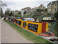
A dream job
The person who runs this Coal Boat on the Kennet and Avon Canal is doing his dream job after spending years travelling the world in his previous job.
Image: © Ian S
Taken: 21 Apr 2013
0.05 miles
7
Former maltings, Sydney Buildings, Bath
On the east bank of the Kennet & Avon Canal.
Image: © Christine Johnstone
Taken: 2 May 2015
0.05 miles
8
Baird's Maltings
Now offices, The Maltings alongside the Kennet & Avon Canal are mid 19th century with 20th century alterations. Listed, grade II, with details at: https://www.historicengland.org.uk/listing/the-list/list-entry/1395233
Image: © Michael Dibb
Taken: 2 Jun 2018
0.05 miles
9
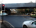
Pulteney Road railway bridge, Bath
Viewed from North Parade Road. About 500 metres NE of Bath Spa railway station,
a bridge carries railway lines over the A36 Pulteney Road.
Image: © Jaggery
Taken: 10 Dec 2012
0.06 miles