IMAGES TAKEN NEAR TO
Brook Road, BATH, BA2 3RR
Introduction
This page details the photographs taken nearby to Brook Road, BA2 3RR by members of the Geograph project.
The Geograph project started in 2005 with the aim of publishing, organising and preserving representative images for every square kilometre of Great Britain, Ireland and the Isle of Man.

There are currently over 7.5m images from over14,400 individuals and you can help contribute to the project by visiting https://www.geograph.org.uk
Image Map
Images are licensed for reuse under creativecommons.org/licenses/by-sa/2.0
Notes
- Clicking on the map will re-center to the selected point.
- The higher the marker number, the further away the image location is from the centre of the postcode.
Image Listing (163 Images Found)
Images are licensed for reuse under creativecommons.org/licenses/by-sa/2.0
Image
Details
Distance
1
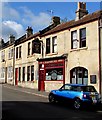
The Charmbury Arms, Bath
Pub at 70 Brook Road in the Twerton area of Bath.
http://www.geograph.org.uk/photo/4512241 to a view of the name sign.
Image: © Jaggery
Taken: 6 Jun 2015
0.01 miles
2
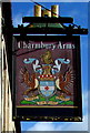
Charmbury Arms name sign, Bath
Located here. http://www.geograph.org.uk/photo/4512226
The Latin motto "palma non sine pulvere" is loosely translated as "No reward without effort".
Image: © Jaggery
Taken: 6 Jun 2015
0.01 miles
3
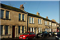
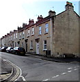
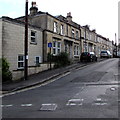
Houses on Brook Road, Twerton
From the junction with Caledonian Road. On the extreme right is the Charmbury Arms Image
Image: © Derek Harper
Taken: 9 Dec 2019
0.01 miles
4
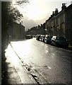
Brook Road, Twerton
Contrejour past the junction with South View Road on the left.
Image: © Derek Harper
Taken: 9 Dec 2019
0.01 miles
5
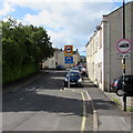
Two similar traffic signs 10 yards apart in Brook Road, Twerton, Bath
The need for one sign showing a 7.5 tonnes vehicle weight limit 110 yards ahead and
a similar sign ten yards away showing the distance as 100 yards in unclear to this observer.
Image: © Jaggery
Taken: 6 Jun 2015
0.03 miles
6
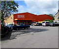
Booker Wholesale, Bath
Set back from the west side of Brook Road. Food wholesaler serving caterers, retailers and other businesses.
Image: © Jaggery
Taken: 6 Jun 2015
0.03 miles
7
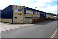
Safestore, Bath
Self-storage (business or personal) premises viewed across Bellotts Road.
Image: © Jaggery
Taken: 6 Jun 2015
0.04 miles
8
Caledonian Road, Bath
Viewed across Brook Road. The large black name sign lists the names of several streets ahead.
Image: © Jaggery
Taken: 6 Jun 2015
0.04 miles
9
Houses on the north side of Caledonian Road, Bath
From Brook Road.
Image: © Jaggery
Taken: 6 Jun 2015
0.04 miles
10
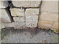
Ordnance Survey Cut Mark
This OS cut mark can be found on the wall of No76 Brook Road. It marks a point 20.795m above mean sea level.
Image: © Adrian Dust
Taken: 3 Dec 2022
0.04 miles