IMAGES TAKEN NEAR TO
Junction Road, BATH, BA2 3NH
Introduction
This page details the photographs taken nearby to Junction Road, BA2 3NH by members of the Geograph project.
The Geograph project started in 2005 with the aim of publishing, organising and preserving representative images for every square kilometre of Great Britain, Ireland and the Isle of Man.

There are currently over 7.5m images from over14,400 individuals and you can help contribute to the project by visiting https://www.geograph.org.uk
Image Map
Images are licensed for reuse under creativecommons.org/licenses/by-sa/2.0
Notes
- Clicking on the map will re-center to the selected point.
- The higher the marker number, the further away the image location is from the centre of the postcode.
Image Listing (117 Images Found)
Images are licensed for reuse under creativecommons.org/licenses/by-sa/2.0
Image
Details
Distance
1

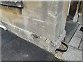
Ordnance Survey Cut Mark
This OS cut mark can be found on the wall of Charcroft, Junction Road. It marks a point 49.034m above mean sea level.
Image: © Adrian Dust
Taken: 2 Dec 2022
0.03 miles
2

St Barts Church, Bath
This name is how it markets itself.
Image: © Bill Boaden
Taken: 29 Jul 2016
0.06 miles
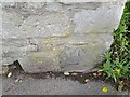
3
Ordnance Survey Cut Mark
This OS cut mark can be found on No51 Upper Oldfield Park. It marks a point 42.889m above mean sea level.
Image: © Adrian Dust
Taken: 2 Dec 2022
0.06 miles
4
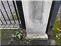
Ordnance Survey Cut Mark
This OS cut mark can be found on the gatepost between No33 & No35 Upper Oldfield Park. It marks a point 48.213m above mean sea level.
Image: © Adrian Dust
Taken: 2 Dec 2022
0.07 miles
5

King Edward Road, Oldfield Park, Bath
Ascending from Third Avenue towards a distant St Barts Church. http://www.geograph.org.uk/photo/5283933
Image: © Jaggery
Taken: 11 Mar 2017
0.07 miles
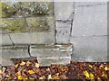
6

Ordnance Survey Cut Mark
This damaged OS cut mark can be found on No1 Livingstone Terrace. It marks a point 42.190m above mean sea level.
Image: © Adrian Dust
Taken: 2 Dec 2022
0.07 miles
7

The Coeur de Lion pub
The Coeur de Lion, located in Northumberland Place just off the High Street, is the smallest pub in Bath and dates back to the 18th century.
Image: © ROWLAND TURNER
Taken: 3 Sep 2012
0.07 miles
8
Ordnance Survey Cut Mark
This OS cut mark can be found on the wall of No30 Oldfield Road. It marks a point 55.360m above mean sea level.
Image: © Adrian Dust
Taken: 2 Dec 2022
0.08 miles
9
Ordnance Survey Cut Mark
This OS cut mark can be found on the wall of Fern Cottage on Oldfield Lane. It marks a point 47.596m above mean sea level.
Image: © Adrian Dust
Taken: 2 Dec 2022
0.11 miles
10
Ordnance Survey Cut Mark
This OS cut mark can be found on No1 Shaftsbury Road. It marks a point 42.456m above mean sea level.
Image: © Adrian Dust
Taken: 2 Dec 2022
0.11 miles