IMAGES TAKEN NEAR TO
Lower Bristol Road, BATH, BA2 3EP
Introduction
This page details the photographs taken nearby to Lower Bristol Road, BA2 3EP by members of the Geograph project.
The Geograph project started in 2005 with the aim of publishing, organising and preserving representative images for every square kilometre of Great Britain, Ireland and the Isle of Man.

There are currently over 7.5m images from over14,400 individuals and you can help contribute to the project by visiting https://www.geograph.org.uk
Image Map
Images are licensed for reuse under creativecommons.org/licenses/by-sa/2.0
Notes
- Clicking on the map will re-center to the selected point.
- The higher the marker number, the further away the image location is from the centre of the postcode.
Image Listing (227 Images Found)
Images are licensed for reuse under creativecommons.org/licenses/by-sa/2.0
Image
Details
Distance
1
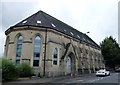
Former church of St Peter on Lower Bristol Road, Bath
The building is now apartments
Image: © Richard Humphrey
Taken: 30 May 2017
0.00 miles
2

St Peter's church
Now converted. A small stream passes right by the circular end and a benchmark can be found at the other - see http://www.geograph.org.uk/photo/2859688.
Image: © Neil Owen
Taken: 8 Mar 2012
0.00 miles
3
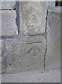
Benchmark on St Peter's
A cutmark, as listed in the Benchmark Database: http://www.bench-marks.org.uk/bm42105 , on the stonework of this old church. See Image] for a wider view.
Image: © Neil Owen
Taken: 8 Mar 2012
0.01 miles
4

Ordnance Survey Cut Mark
This OS cut mark can be found on the NW angle of St Peter's Church. It marks a point 19.761m above mean sea level.
Image: © Adrian Dust
Taken: 3 Dec 2022
0.01 miles
5

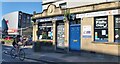
The Victoria Works public house in Lower Bristol Road
There was considerable outrage locally when the pub name was changed from the Belvoir Castle in 2010. Under a change of ownership the name has reverted to its original since this photo was taken.
Image: © Rod Allday
Taken: 4 Mar 2013
0.01 miles
7

St Peter's school and hall
Located beside St Peter's church, the school has branched out into larger premises. See VVVV for a wider view of the older part.
Image: © Neil Owen
Taken: 20 Jan 2023
0.02 miles
8

Part of the old school
The grand appearance of Oldfield Park Infants School, built in 1888; the more modern part is to its left. See CCCCC for the date stone.
Image: © Neil Owen
Taken: 20 Jan 2023
0.03 miles
9
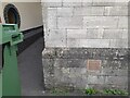
Ordnance Survey Cut Mark
This OS cut mark can be found on the north angle of the school on Dorset Street. It marks a point 21.506m above mean sea level.
Image: © Adrian Dust
Taken: 3 Dec 2022
0.04 miles
10
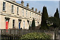
Terraced houses in Lower Bristol Road Bath
Image: © Rod Allday
Taken: 4 Mar 2013
0.05 miles