IMAGES TAKEN NEAR TO
Lower Bristol Road, BATH, BA2 3ED
Introduction
This page details the photographs taken nearby to Lower Bristol Road, BA2 3ED by members of the Geograph project.
The Geograph project started in 2005 with the aim of publishing, organising and preserving representative images for every square kilometre of Great Britain, Ireland and the Isle of Man.

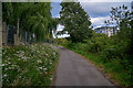
There are currently over 7.5m images from over14,400 individuals and you can help contribute to the project by visiting https://www.geograph.org.uk
Image Map
Images are licensed for reuse under creativecommons.org/licenses/by-sa/2.0
Notes
- Clicking on the map will re-center to the selected point.
- The higher the marker number, the further away the image location is from the centre of the postcode.
Image Listing (125 Images Found)
Images are licensed for reuse under creativecommons.org/licenses/by-sa/2.0
Image
Details
Distance
1
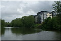
River Avon below Weston Bridge
Looking upstream from near Halfpenny Bridge. On the south bank is Bath Spa University's Waterside Court halls.
Image: © Pierre Terre
Taken: 21 May 2006
0.02 miles
2
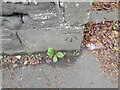
Ordnance Survey Cut Mark
This OS cut mark can be found on the wall of No21 Vernon Terrace. It marks a point 18.939m above mean sea level.
Image: © Adrian Dust
Taken: 3 Dec 2022
0.03 miles
3
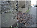
Benchmark on the Lower Bristol Road
Old Victorian terraced houses line this side of the main road and a benchmark on the stonework must date from shortly after this part of Twerton was constructed. See https://www.bench-marks.org.uk/bm105656 for the entry in the Benchmark Database.
Image: © Neil Owen
Taken: 20 Jan 2023
0.03 miles
4
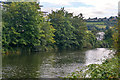
Bath : The River Avon
Looking along the River Avon.
Image: © Lewis Clarke
Taken: 6 Aug 2020
0.04 miles
5
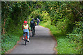
Bath : Bath Bristol Cycle Track
Looking along the footpath.
Image: © Lewis Clarke
Taken: 6 Aug 2020
0.04 miles
6
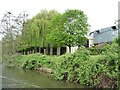
Factory on Locksbrook Road, Bath
With a well-maintained river frontage.
Image: © Christine Johnstone
Taken: 3 May 2015
0.05 miles
7

Trimmed for the new year
A rather stark appearance for these trees.
Image: © Neil Owen
Taken: 20 Jan 2023
0.08 miles
8
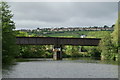
Bath & Bristol Railway Bridge, Weston, Bath
Disused railway bridge over the Avon above Weston Cut. View downstream, with Twerton and Whiteway beyond.
Image: © Pierre Terre
Taken: 20 May 2006
0.08 miles
9
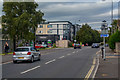
Bath : Lower Bristol Road A36
Looking along Lower Bristol Road.
Image: © Lewis Clarke
Taken: 6 Aug 2020
0.08 miles
10
Bath : Bath Bristol Cycle Track
A track heads alongside the river.
Image: © Lewis Clarke
Taken: 6 Aug 2020
0.09 miles