IMAGES TAKEN NEAR TO
Lower Bristol Road, BATH, BA2 3BG
Introduction
This page details the photographs taken nearby to Lower Bristol Road, BA2 3BG by members of the Geograph project.
The Geograph project started in 2005 with the aim of publishing, organising and preserving representative images for every square kilometre of Great Britain, Ireland and the Isle of Man.

There are currently over 7.5m images from over14,400 individuals and you can help contribute to the project by visiting https://www.geograph.org.uk
Image Map
Images are licensed for reuse under creativecommons.org/licenses/by-sa/2.0
Notes
- Clicking on the map will re-center to the selected point.
- The higher the marker number, the further away the image location is from the centre of the postcode.
Image Listing (247 Images Found)
Images are licensed for reuse under creativecommons.org/licenses/by-sa/2.0
Image
Details
Distance
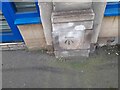
1

Benchmark on the Lower Bristol Road
Located on a motoring accessory shop, this cut mark has withstood a fair amount of traffic pollution.
See http://www.bench-marks.org.uk/bm37654 for the Benchmark Database.
Image: © Neil Owen
Taken: 12 Apr 2011
0.00 miles
2
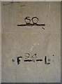
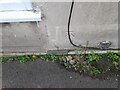
Curious marks
Devoid of any immediate description, these marks appear on an otherwise inconspicuous wall. Compare them to the marks found just a short walk away Image Are these records of floodings?
Image: © Neil Owen
Taken: 12 Apr 2011
0.02 miles
3

Westmoreland Street, Bath
Site of some interesting marks carved and hammered into the wall. See Image] for a closer inspection.
Image: © Neil Owen
Taken: 12 Apr 2011
0.02 miles
4
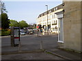
Sydenham, Buildings, Bath
A modern telephone box has taken advantage of the closure of this road. On the wall to the right are some interesting masons' marks, and a benchmark.
See Image] for the masons', and Image] for the benchmark.
Image: © Neil Owen
Taken: 12 Apr 2011
0.02 miles
5
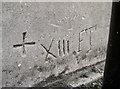
Masons' marks, Sydenham Road
A nice collection of marks found close to the ground on a small shop wall. See Image] for view of the location fronting onto the Lower Bristol Road.
Image: © Neil Owen
Taken: 12 Apr 2011
0.02 miles
6
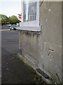
Cut benchmark, Sydenham Road
Located at the end of a minor road as it opens onto the Lower Bristol Road. See Image] for a wider view.
See http://www.bench-marks.org.uk/bm37653 for the Benchmark Database listing.
Image: © Neil Owen
Taken: 12 Apr 2011
0.02 miles
7
Ordnance Survey Cut Mark
This OS cut mark can be found on No80 Lower Bristol Road. It marks a point 19.106m above mean sea level.
Image: © Adrian Dust
Taken: 3 Dec 2022
0.02 miles
8
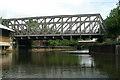
Midland Bridge Road Bridge, River Avon, Bath
Carrying Midland Bridge Road between Kingsmead and Westmoreland.
Image: © Pierre Terre
Taken: 20 May 2006
0.02 miles
9
Ordnance Survey Cut Mark
This OS cut mark can be found on the junction between No69 & No70 Lower Bristol Road. It marks a point 19.095m above mean sea level.
Image: © Adrian Dust
Taken: 3 Dec 2022
0.03 miles
10
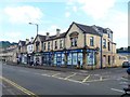
Buildings in Lower Bristol Road
This fine range of shops with living accommodation above is wholly spoilt by the opaquing of the shop windows.
Image: © Michael Dibb
Taken: 2 Jun 2018
0.03 miles