IMAGES TAKEN NEAR TO
Maple Gardens, BATH, BA2 3AG
Introduction
This page details the photographs taken nearby to Maple Gardens, BA2 3AG by members of the Geograph project.
The Geograph project started in 2005 with the aim of publishing, organising and preserving representative images for every square kilometre of Great Britain, Ireland and the Isle of Man.

There are currently over 7.5m images from over14,400 individuals and you can help contribute to the project by visiting https://www.geograph.org.uk
Image Map
Images are licensed for reuse under creativecommons.org/licenses/by-sa/2.0
Notes
- Clicking on the map will re-center to the selected point.
- The higher the marker number, the further away the image location is from the centre of the postcode.
Image Listing (81 Images Found)
Images are licensed for reuse under creativecommons.org/licenses/by-sa/2.0
Image
Details
Distance
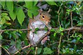
1
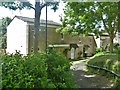
Housing in Durley Park
Not the best designed houses.
Image: © Michael Dibb
Taken: 2 Jun 2018
0.06 miles
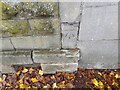
2
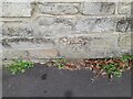
Ordnance Survey Cut Mark
This OS cut mark can be found on the wall north side of Dursley Park. It marks a point 38.563m above mean sea level.
Image: © Adrian Dust
Taken: 2 Dec 2022
0.08 miles
3
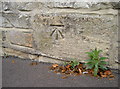
Benchmark in Oldfield Lane
A cutmark, as listed in the Benchmark Database http://www.bench-marks.org.uk/bm39815 , in Oldfield Lane close to the junction with First Avenue. Interestingly there appears to be a DPC below it, giving rise to suspicions that it has been repositioned on site when the wall was rebuilt. The OS lists it as being here, but the accuracy must surely be questioned.
Image: © Neil Owen
Taken: 17 Oct 2011
0.08 miles
4
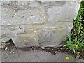
Ordnance Survey Cut Mark
This OS cut mark can be found on the wall of Fern Cottage on Oldfield Lane. It marks a point 47.596m above mean sea level.
Image: © Adrian Dust
Taken: 2 Dec 2022
0.08 miles
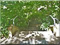
5
Bath : Squirrel
A squirrel seen alongside the footpath.
Image: © Lewis Clarke
Taken: 6 Aug 2020
0.09 miles
6
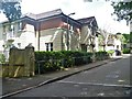
Housing in Hiscocks Drive
A fairly recent development.
Image: © Michael Dibb
Taken: 2 Jun 2018
0.09 miles
7
Down to the road
These steps provide access to Hiscocks Drive from the Two Tunnels Greenway.
The Greenway is the former trackbed of the Somerset & Dorset Joint Railway which ran from Bath to Bournemouth. The heavily engineered railway closed in 1966. Part of the trackbed became a linear park whilst further south it was used as an informal footpath. A campaign to re-open the route as a shared-use path started in 2005 and the Two Tunnels Greenway opened in April, 2013.
Image: © Michael Dibb
Taken: 2 Jun 2018
0.09 miles
8
![Over the road [2]](https://s0.geograph.org.uk/geophotos/05/81/25/5812588_410a8adb_120x120.jpg)
Over the road [2]
The three arch bridge carries the Two Tunnels Greenway over Hiscocks Drive.
The Greenway is the former trackbed of the Somerset & Dorset Joint Railway which ran from Bath to Bournemouth. The heavily engineered railway closed in 1966. Part of the trackbed became a linear park whilst further south it was used as an informal footpath. A campaign to re-open the route as a shared-use path started in 2005 and the Two Tunnels Greenway opened in April, 2013.
Image: © Michael Dibb
Taken: 2 Jun 2018
0.09 miles
9
![Over the road [1]](https://s2.geograph.org.uk/geophotos/05/81/25/5812578_18027955_120x120.jpg)
Over the road [1]
The three arch bridge carries the Two Tunnels Greenway over Hiscocks Drive.
The Greenway is the former trackbed of the Somerset & Dorset Joint Railway which ran from Bath to Bournemouth. The heavily engineered railway closed in 1966. Part of the trackbed became a linear park whilst further south it was used as an informal footpath. A campaign to re-open the route as a shared-use path started in 2005 and the Two Tunnels Greenway opened in April, 2013.
Image: © Michael Dibb
Taken: 2 Jun 2018
0.09 miles
10
Ordnance Survey Cut Mark
This OS cut mark can be found on the wall of No30 Oldfield Road. It marks a point 55.360m above mean sea level.
Image: © Adrian Dust
Taken: 2 Dec 2022
0.09 miles