
IMAGES TAKEN NEAR TO
Rush Hill, BATH, BA2 2QT
Introduction
This page details the photographs taken nearby to Rush Hill, BA2 2QT by members of the Geograph project.
The Geograph project started in 2005 with the aim of publishing, organising and preserving representative images for every square kilometre of Great Britain, Ireland and the Isle of Man.

There are currently over 7.5m images from over14,400 individuals and you can help contribute to the project by visiting https://www.geograph.org.uk
Image Map
Images are licensed for reuse under creativecommons.org/licenses/by-sa/2.0
Notes
- Clicking on the map will re-center to the selected point.
- The higher the marker number, the further away the image location is from the centre of the postcode.
Image Listing (12 Images Found)
Images are licensed for reuse under creativecommons.org/licenses/by-sa/2.0
Image
Details
Distance
1
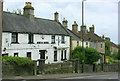
2008 : The Rose and Laurel, Rush Hill
Well positioned about half way up Rush Hill.
An old country inn now swallowed by Bath suburbs.
The Rose and the Laurel is the quick march of the British Armed Forces Intelligence Corps. They know a thing or two.
The bold red shield under the eaves tells us this is an "Ushers" house.
Image: © Maurice Pullin
Taken: 10 Jul 2008
0.06 miles
2
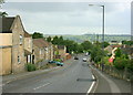
2008 : Rush Hill, Bath
Near the bottom of Rush Hill. At the next crossroads it becomes Whiteway Road which continues to the A4 at Newton St.Loe.
Directly ahead on the skyline we have, left to right, Winsbury Hill and Stantonbury Hill Image which are near Stanton Prior.
Image: © Maurice Pullin
Taken: 10 Jul 2008
0.08 miles
3
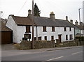
Another case of 'Time gentlemen, please!'
The old Rose and Laurel on Rush Hill has now closed its doors. It is up for sale, although the prospects for this old inn seem uncertain in these pressing times. See Maurice Pullin's shot of 2008 Image] for an earlier view.
Image: © Neil Owen
Taken: 9 Feb 2012
0.08 miles
4
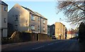
Rush Hill
A busy road, momentarily free of traffic, here descending from Odd Down past a cul-de-sac of the same name, and housing old and new.
Image: © Derek Harper
Taken: 16 Feb 2016
0.10 miles
5
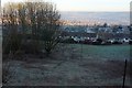
View from Rush Hill
From the junction with Summerdale View / Somerdale View (both spellings appear on maps). The houses across the open hillside are on Edgeworth Road.
Image: © Derek Harper
Taken: 16 Feb 2016
0.10 miles
6
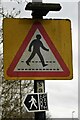
'Walk Away'
An image of two 'public information' signs, attached to the same lamppost.
With a different sized, if similar figure on both of the roadside signs
'Walking' in the opposite direction to each other?
The top one advises there is a pedestrian crossing nearby.
The one below directs one to or along a nearby 'public footpath'.
Signs like these are seen in plain sight, often enough to 'disappear': blend.
Image: © D M Wilmot
Taken: 16 Mar 2021
0.11 miles
7
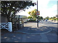
Culverhay School
The school was under threat of closure a couple of years ago, but after a new local council was elected it was reprieved.
[2018 update: the Bath Community Academy (as it now is) will close at the end of the summer 2018 term, because of low pupil numbers]
Image: © HelenK
Taken: 10 Oct 2013
0.13 miles
8
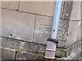
Ordnance Survey Cut Mark
This OS cut mark can be found on No237 Englishcombe Lane. It marks a point 101.214m above mean sea level.
Image: © Adrian Dust
Taken: 2 Dec 2022
0.20 miles
9
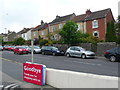
Houses on Englishcombe lane
A mixture of terraced and semi detached houses line this old route out of the city of Bath. The goodbye sign belongs to a Tesco Express store opposite the houses.
Image: © Nigel Mykura
Taken: 30 Sep 2012
0.22 miles
10

Ordnance Survey Cut Mark
This OS cut mark can be found on the wall SW side of Englishcombe Lane. It marks a point 90.936m above mean sea level.
Image: © Adrian Dust
Taken: 2 Dec 2022
0.23 miles