IMAGES TAKEN NEAR TO
Westfield Close, BATH, BA2 2EA
Introduction
This page details the photographs taken nearby to Westfield Close, BA2 2EA by members of the Geograph project.
The Geograph project started in 2005 with the aim of publishing, organising and preserving representative images for every square kilometre of Great Britain, Ireland and the Isle of Man.

There are currently over 7.5m images from over14,400 individuals and you can help contribute to the project by visiting https://www.geograph.org.uk
Image Map
Images are licensed for reuse under creativecommons.org/licenses/by-sa/2.0
Notes
- Clicking on the map will re-center to the selected point.
- The higher the marker number, the further away the image location is from the centre of the postcode.
Image Listing (14 Images Found)
Images are licensed for reuse under creativecommons.org/licenses/by-sa/2.0
Image
Details
Distance
1
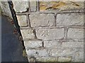
Ordnance Survey Cut Mark
This OS cut mark can be found on the wall of No204 Bloomfield Road. It marks a point 115.348m above mean sea level.
Image: © Adrian Dust
Taken: 16 Nov 2022
0.06 miles
2
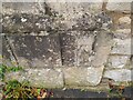
Ordnance Survey Cut Mark
This OS cut mark can be found on the wall of Westfield House. It marks a point 102.779m above mean sea level.
Image: © Adrian Dust
Taken: 16 Nov 2022
0.08 miles
3
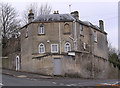
Tollhouse by Bloomfield Road, Bath
Tollhouse in the parish of Bath (Bath and North East Somerset District), Westfield Cottage, No. 150, Bloomfield Road, BA2.
Grade II listed.
List Entry Number: 1394781 https://historicengland.org.uk/listing/the-list/list-entry/1394781
Surveyed
Milestone Society National ID: AV.BAT02
Image: © Alan Rosevear
Taken: 30 Jan 2005
0.14 miles
4
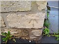
Ordnance Survey Cut Mark
This OS cut mark can be found on the wall of Westfield Cottage. It marks a point 94.045m above mean sea level.
Image: © Adrian Dust
Taken: 16 Nov 2022
0.15 miles
5
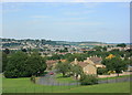
2008 : North east from Englishcombe Lane
Turning clockwise from Image] Chantry Mead is in the foreground. The centre of Bath is in the middle of the frame, further over and slightly to the right Little Solsbury Hill Image appears. Left from there we have part of Charmy Down then the slope up to Lansdown. St.Stephen's Church, sans scaffolding, is there but not easily seen.
Image: © Maurice Pullin
Taken: 24 Jul 2008
0.15 miles
6
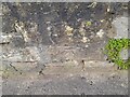
Ordnance Survey Cut Mark
This OS cut mark can be found on the wall of No234 Bloomfield Road. It marks a point 136.111m above mean sea level.
Image: © Adrian Dust
Taken: 16 Nov 2022
0.16 miles
7
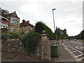
Edwardian houses on Englishcombe Lane
These houses enjoy impressive views towards the northern side of Bath. The ironwork around the balconies of some of them is - rather unusually for Bath - in Art Nouveau style.
Image: © HelenK
Taken: 14 Sep 2013
0.18 miles
8
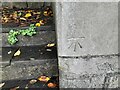
Ordnance Survey Cut Mark
This OS cut mark can be found on the wall of Hatfield Place. It marks a point 88.580m above mean sea level.
Image: © Adrian Dust
Taken: 16 Nov 2022
0.20 miles
9
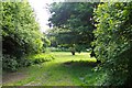
Who's pinched my tunnel?!
This grassy glade in the southern suburbs of Bath marks the spot where the northern portal of the Somerset & Dorset Railway's Devonshire Tunnel once stood. It has now been buried by infilling the approach cutting. In the middle of the picture is a manhole which gives access to it so that occasional inspections can be carried out.
Image: © Ron Strutt
Taken: 15 May 2005
0.24 miles