IMAGES TAKEN NEAR TO
Street Lane, YEOVIL, BA22 9SP
Introduction
This page details the photographs taken nearby to Street Lane, BA22 9SP by members of the Geograph project.
The Geograph project started in 2005 with the aim of publishing, organising and preserving representative images for every square kilometre of Great Britain, Ireland and the Isle of Man.

There are currently over 7.5m images from over14,400 individuals and you can help contribute to the project by visiting https://www.geograph.org.uk
Image Map
Images are licensed for reuse under creativecommons.org/licenses/by-sa/2.0
Notes
- Clicking on the map will re-center to the selected point.
- The higher the marker number, the further away the image location is from the centre of the postcode.
Image Listing (6 Images Found)
Images are licensed for reuse under creativecommons.org/licenses/by-sa/2.0
Image
Details
Distance
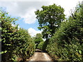
1

Landshire Lane
A muddy back lane covered in mud due to the heavy rain and extensive ploughing activity in nearby fields.in the distance is one of the houses near Street Lane Farm.
Image: © Nigel Mykura
Taken: 30 Jan 2016
0.09 miles
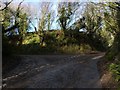
3
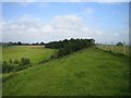
Footpath between Odcombe and East Chinnock
Image: © Becky Williamson
Taken: 15 Jan 2015
0.16 miles
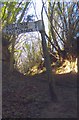
4
Stump Stone, East Chinnock
I was disappointed not to discover any stone here. The name had intrigued me!
Image: © Becky Williamson
Taken: 15 Jan 2015
0.22 miles
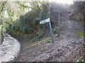
5
Old Direction Sign - Signpost by Stump Stone, East Chinnock Parish
Lost finial - 1 arm; by the UC road, in parish of East Chinnock (District), Stump Stone, by junction of Green Lane with Copse Lane, just South of Chiselborough Hill, Landshire Lane and Green Lane junction, by steep roadside bank.
Surveyed
Milestone Society National ID: SO_ST4914
Image: © Milestone Society
Taken: Unknown
0.24 miles
6
Odcombe Tip
The flat field to the left of the trees is part of the Odcombe landfill site. Now all green and pleasant, well on the surface anyway!
Image: © Rupert Fleetingly
Taken: 1 Jul 2007
0.25 miles