IMAGES TAKEN NEAR TO
Sutton Montis, YEOVIL, BA22 7HG
Introduction
This page details the photographs taken nearby to BA22 7HG by members of the Geograph project.
The Geograph project started in 2005 with the aim of publishing, organising and preserving representative images for every square kilometre of Great Britain, Ireland and the Isle of Man.

There are currently over 7.5m images from over14,400 individuals and you can help contribute to the project by visiting https://www.geograph.org.uk
Image Map
Images are licensed for reuse under creativecommons.org/licenses/by-sa/2.0
Notes
- Clicking on the map will re-center to the selected point.
- The higher the marker number, the further away the image location is from the centre of the postcode.
Image Listing (8 Images Found)
Images are licensed for reuse under creativecommons.org/licenses/by-sa/2.0
Image
Details
Distance
1
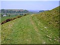
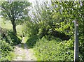
On Corton Ridge
The bridleway and sheep track rounding Parrock Hill, looking north towards Cadbury Castle.
Image: © Graham Horn
Taken: 5 May 2007
0.19 miles

3
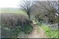
Green lane, Sutton Montis
A track running over the shoulder of Parrock Hill.
Image: © Richard Webb
Taken: 7 Apr 2015
0.23 miles
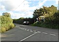
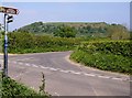
6
Bridleway to Parrock Hill
At a minor road junction, a bridleway heads south, level aty first then after the first gate just visible it climbs steeply up Parrock Hill onto Corton Ridge. The blue writing running down the post says "Stafford's Green 2m".
Image: © Graham Horn
Taken: 5 May 2007
0.25 miles
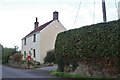
7
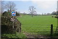
Field, Sutton Montis
A grassy hill at the foot of the lias escarpment. There is a new sign recommending not using the road with HGVs - these are common in Somerset and a response to the use of GPS navigation.
Image: © Richard Webb
Taken: 7 Apr 2015
0.25 miles
8
Byway and cycle route towards Cadbury Castle
At the end of the bridleway coming off Corton Ridge and Parrock Hill from the south. The minor road is used by the Macmillan Way and National Cycle Network route 26. They head towards South Cadbury, the access point for Cadbury Castle seen dominating the horizon.
Image: © Graham Horn
Taken: 5 May 2007
0.25 miles