
IMAGES TAKEN NEAR TO
Kelston View, BATH, BA2 1NP
Introduction
This page details the photographs taken nearby to Kelston View, BA2 1NP by members of the Geograph project.
The Geograph project started in 2005 with the aim of publishing, organising and preserving representative images for every square kilometre of Great Britain, Ireland and the Isle of Man.

There are currently over 7.5m images from over14,400 individuals and you can help contribute to the project by visiting https://www.geograph.org.uk
Image Map
Images are licensed for reuse under creativecommons.org/licenses/by-sa/2.0
Notes
- Clicking on the map will re-center to the selected point.
- The higher the marker number, the further away the image location is from the centre of the postcode.
Image Listing (4 Images Found)
Images are licensed for reuse under creativecommons.org/licenses/by-sa/2.0
Image
Details
Distance
1
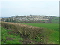
Twerton seen from the west
Twerton seen from the hillside east of Newton St Loe.
Image: © James Ayres
Taken: 10 Apr 2010
0.11 miles
2
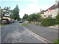
Haycombe Drive
A view along a street in this housing estate. Bath is not a city of football supporters, but a Manchester United fan lives in a house on the right.
Image: © HelenK
Taken: 10 Oct 2013
0.15 miles
3

Cut benchmark on a pillar, Haycombe Cemetery
One of two marks on pillars along Whiteway Road, this being near to the bottom of the old grounds. The other can be seen here: Image], and both are listed in the Benchmark Database: http://www.bench-marks.org.uk/bm39522 .
Image: © Neil Owen
Taken: 10 Sep 2011
0.24 miles
4
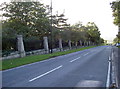
Whiteway Road, Bath
Looking down the steep hill towards Pennyquick and Clay's End, the extent of Haycombe Cemetery can be followed by the stone pillars. Recently, the field adjacent has been fettled for more burials - a necessary extension as the current land is close to capacity. A benchmark can be found on a pillar near to the end:Image
Image: © Neil Owen
Taken: 10 Sep 2011
0.25 miles