IMAGES TAKEN NEAR TO
Highland Road, BATH, BA2 1DY
Introduction
This page details the photographs taken nearby to Highland Road, BA2 1DY by members of the Geograph project.
The Geograph project started in 2005 with the aim of publishing, organising and preserving representative images for every square kilometre of Great Britain, Ireland and the Isle of Man.

There are currently over 7.5m images from over14,400 individuals and you can help contribute to the project by visiting https://www.geograph.org.uk
Image Map
Images are licensed for reuse under creativecommons.org/licenses/by-sa/2.0
Notes
- Clicking on the map will re-center to the selected point.
- The higher the marker number, the further away the image location is from the centre of the postcode.
Image Listing (43 Images Found)
Images are licensed for reuse under creativecommons.org/licenses/by-sa/2.0
Image
Details
Distance
1
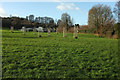
Innox Park
Looking right from Image The houses are on Freeview Road.
Image: © Derek Harper
Taken: 9 Dec 2019
0.03 miles
2

Innox Park
The northeast corner of the park, as footpath BC 24/23#1 (one of several crossing it) leaves onto Shophouse Road. There's a view across the Avon valley.
Image: © Derek Harper
Taken: 9 Dec 2019
0.05 miles
3

Innox Park
The path, with its chicane entrance, is shown in Image Trees screen allotments and Bath City Farm up the hill.
Image: © Derek Harper
Taken: 9 Dec 2019
0.05 miles
4

Innox Park
Footpath BC 24/24 entering the park from The Brow.
Image: © Derek Harper
Taken: 9 Dec 2019
0.05 miles
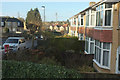
5

Shophouse Road, Twerton
Freshly washed by a heavy shower or two. This is by the corner of Innox Road.
Image: © Derek Harper
Taken: 9 Dec 2019
0.08 miles
6
Shophouse Road, Twerton
From Priddy Close. The floodlights are at Twerton Park Football Ground, the home of Bath City FC.
Image: © Derek Harper
Taken: 9 Dec 2019
0.10 miles
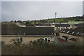
7

2008 : Bath City F.C. Stadium
Seen from Kelston View, Whiteway. http://www.bathcityfc.com/index_newkit.htm
Parts of Twerton and Lower Weston are in the background.
Image: © Maurice Pullin
Taken: 14 Jul 2008
0.11 miles
8
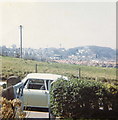
1969 Twerton With Bath City Football Ground
A picture taken from Lansdown View looking towards Bristol showing a view of Twerton village, prior to the large housing developments being built. A view which is now obscured and much changed.
Image: © Keith Carpenter
Taken: Unknown
0.11 miles
10

Twerton on Avon railway station (site), Bath
Opened in 1840 as Twerton by the Great Western Railway on the line from Bath Spa to Bristol Temple Meads, this station was renamed in 1899 to Twerton on Avon to avoid any possible confusion with Tiverton. It closed in 1917.
View west towards Saltford and Bristol, from Lower Bristol Road.
Image: © Nigel Thompson
Taken: 31 Mar 2018
0.15 miles