IMAGES TAKEN NEAR TO
Dominion Road, BATH, BA2 1DF
Introduction
This page details the photographs taken nearby to Dominion Road, BA2 1DF by members of the Geograph project.
The Geograph project started in 2005 with the aim of publishing, organising and preserving representative images for every square kilometre of Great Britain, Ireland and the Isle of Man.

There are currently over 7.5m images from over14,400 individuals and you can help contribute to the project by visiting https://www.geograph.org.uk
Image Map
Images are licensed for reuse under creativecommons.org/licenses/by-sa/2.0
Notes
- Clicking on the map will re-center to the selected point.
- The higher the marker number, the further away the image location is from the centre of the postcode.
Image Listing (55 Images Found)
Images are licensed for reuse under creativecommons.org/licenses/by-sa/2.0
Image
Details
Distance
2

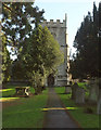
Twerton churchyard
The northeastern corner of the churchyard of St Michael and All Angels, with houses on How Hill in the background. A branch on the tree has been prudently lopped to avoid it falling some way onto the road below the churchyard wall.
Image: © Derek Harper
Taken: 9 Dec 2019
0.07 miles
3

Old Milestone, High Street, Twerton
Stone post (plate lost) by the UC road (was A39), in parish of BATH (BATH AND NORTH EAST SOMERSET District), High Street, Twerton, at corner of Clyde Gardens, end of stone retaining wall, on North side of road. Bath iron plate erected by the Bath turnpike trust in the 18th century.
Inscription once read:-
To
BATH
2
Milestone Society National ID: SO_BAGL02.
Image: © JR Dowding
Taken: 7 Jan 2012
0.07 miles
4
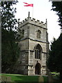
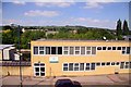
Church of St Michael and All Angels, Twerton
Grade II* listed and described at https://historicengland.org.uk/listing/the-list/list-entry/1395896 . "C15 tower, remainder of church rebuilt in Perpendicular detail in 1839. By GP Manners, rebuilt again to designs of EW Buckle, 1885-1886, at cost of £2600, but incorporating C12 North doorway ... This is a very complete version of a late mediaeval church created in the C19 ..."
Image: © Derek Harper
Taken: 9 Dec 2019
0.07 miles
5
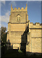
Church of St Michael and All Angels, Twerton
The tower of the grade II* listed church is C15; apart from a C12 doorway, the rest is C19: "a very complete version of a late mediaeval church created in the C19, both before the main thrust of Tractarianism and Ecclesiology had made their mark, and again after they had spent their main force" https://historicengland.org.uk/listing/the-list/list-entry/1395896 .
Image: © Derek Harper
Taken: 9 Dec 2019
0.07 miles
6
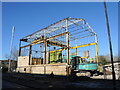
Steel skeleton of the old warehouse
The former Hollis Industries warehouse was a post-war creation beside the banks of the Avon. However, the original occupiers have left and the building was taken over by a local charity. Now they too have relocated and the site is being torn down.
Image: © Neil Owen
Taken: 20 Jan 2023
0.08 miles
8
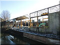
They'll have a great view by the river
Hollis Industries built the old warehouse but have since reliquished it. Now redundant, the structure is being flattened and student accommodation is due to replace it.
Image: © Neil Owen
Taken: 20 Jan 2023
0.08 miles
9
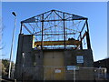
The end from the end
The old Hollis Industries warehouse is being brought down, bit by bit. Plans have apparently already been approved for a new student accommodation block to replace it.
Image: © Neil Owen
Taken: 20 Jan 2023
0.08 miles
10
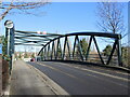
The bridge to bus island
The island in the middle of the Avon is largely occupied by the premises of First Buses in Bath. A suitably sturdy bridge spans the waters. In the past the island was home to woollen and wood mills, and allotments.
Image: © Neil Owen
Taken: 20 Jan 2023
0.08 miles