IMAGES TAKEN NEAR TO
High Street, BATH, BA2 1DB
Introduction
This page details the photographs taken nearby to High Street, BA2 1DB by members of the Geograph project.
The Geograph project started in 2005 with the aim of publishing, organising and preserving representative images for every square kilometre of Great Britain, Ireland and the Isle of Man.

There are currently over 7.5m images from over14,400 individuals and you can help contribute to the project by visiting https://www.geograph.org.uk
Image Map
Images are licensed for reuse under creativecommons.org/licenses/by-sa/2.0
Notes
- Clicking on the map will re-center to the selected point.
- The higher the marker number, the further away the image location is from the centre of the postcode.
Image Listing (62 Images Found)
Images are licensed for reuse under creativecommons.org/licenses/by-sa/2.0
Image
Details
Distance
2

Old Milestone, High Street, Twerton
Stone post (plate lost) by the UC road (was A39), in parish of BATH (BATH AND NORTH EAST SOMERSET District), High Street, Twerton, at corner of Clyde Gardens, end of stone retaining wall, on North side of road. Bath iron plate erected by the Bath turnpike trust in the 18th century.
Inscription once read:-
To
BATH
2
Milestone Society National ID: SO_BAGL02.
Image: © JR Dowding
Taken: 7 Jan 2012
0.04 miles
3
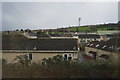
1969 Twerton With Bath City Football Ground
A picture taken from Lansdown View looking towards Bristol showing a view of Twerton village, prior to the large housing developments being built. A view which is now obscured and much changed.
Image: © Keith Carpenter
Taken: Unknown
0.05 miles
4

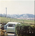
2008 : Bath City F.C. Stadium
Seen from Kelston View, Whiteway. http://www.bathcityfc.com/index_newkit.htm
Parts of Twerton and Lower Weston are in the background.
Image: © Maurice Pullin
Taken: 14 Jul 2008
0.08 miles
5
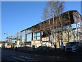
Clearing out the old warehouse
An industrial building along the Lower Bristol Road has come to the end of its life.
Image: © Neil Owen
Taken: 20 Jan 2023
0.10 miles
6

Weir at Weston Lock on the River Avon.
This is the weir beside Locksbrook, on the Western side of Bath.
Image: © Martyn Pattison
Taken: 3 Aug 2005
0.10 miles
7

Bath And North East Somerset : Bath Scenery
Looking down towards the city of Bath.
Image: © Lewis Clarke
Taken: 18 Jun 2017
0.10 miles
8
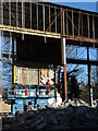
Picking iron cherries
A motorised platform trundles inside the old warehouse, looking for another tasty target to rip down. The site is due to be redeveloped as yet more student accommodation.
Image: © Neil Owen
Taken: 20 Jan 2023
0.10 miles
9
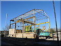
Steel skeleton of the old warehouse
The former Hollis Industries warehouse was a post-war creation beside the banks of the Avon. However, the original occupiers have left and the building was taken over by a local charity. Now they too have relocated and the site is being torn down.
Image: © Neil Owen
Taken: 20 Jan 2023
0.12 miles
10
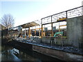
They'll have a great view by the river
Hollis Industries built the old warehouse but have since reliquished it. Now redundant, the structure is being flattened and student accommodation is due to replace it.
Image: © Neil Owen
Taken: 20 Jan 2023
0.12 miles