IMAGES TAKEN NEAR TO
Claude Terrace, BATH, BA2 1AB
Introduction
This page details the photographs taken nearby to Claude Terrace, BA2 1AB by members of the Geograph project.
The Geograph project started in 2005 with the aim of publishing, organising and preserving representative images for every square kilometre of Great Britain, Ireland and the Isle of Man.

There are currently over 7.5m images from over14,400 individuals and you can help contribute to the project by visiting https://www.geograph.org.uk
Image Map
Images are licensed for reuse under creativecommons.org/licenses/by-sa/2.0
Notes
- Clicking on the map will re-center to the selected point.
- The higher the marker number, the further away the image location is from the centre of the postcode.
Image Listing (120 Images Found)
Images are licensed for reuse under creativecommons.org/licenses/by-sa/2.0
Image
Details
Distance
1
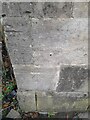
Ordnance Survey Cut Mark
This OS cut mark can be found on the Public Convenience on Claude Avenue. It marks a point 46.260m above mean sea level.
Image: © Adrian Dust
Taken: 2 Dec 2022
0.02 miles
2
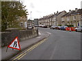
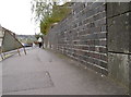
Small roadworks on Bridge Road
This busy bus route remains clear enough whilst the work continues. A benchmark can be found on the stone section after the dark brickwork; see Image The bridge is in fact over the old minor branch railway line from Green Park, further into Bath; the old track is now a pathway; see Image] for a view.
Image: © Neil Owen
Taken: 17 Oct 2011
0.03 miles
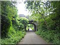
3
![Bridge over the greenway [1]](https://s3.geograph.org.uk/geophotos/05/81/25/5812555_47e0d0fe_120x120.jpg)
Bridge over the greenway [1]
The bridge carries Claude Avenue over the Two Tunnels Greenway, here looking southeast. The bridge has obviously been widened.
The Greenway is the former trackbed of the Somerset & Dorset Joint Railway which ran from Bath to Bournemouth. The heavily engineered railway closed in 1966. Part of the trackbed became a linear park whilst further south it was used as an informal footpath. A campaign to re-open the route as a shared-use path started in 2005 and the Two Tunnels Greenway opened in April, 2013.
Image: © Michael Dibb
Taken: 2 Jun 2018
0.03 miles
4
![Bridge over the greenway [2]](https://s0.geograph.org.uk/geophotos/05/81/25/5812556_13fd7e65_120x120.jpg)
Bridge over the greenway [2]
The bridge carries Claude Avenue over the Two Tunnels Greenway, here looking northwest. The bridge has obviously been widened.
The Greenway is the former trackbed of the Somerset & Dorset Joint Railway which ran from Bath to Bournemouth. The heavily engineered railway closed in 1966. Part of the trackbed became a linear park whilst further south it was used as an informal footpath. A campaign to re-open the route as a shared-use path started in 2005 and the Two Tunnels Greenway opened in April, 2013.
Image: © Michael Dibb
Taken: 2 Jun 2018
0.03 miles
5
Bridge carrying Claude Avenue over NCN244
Following the old railway line (Two Tunnels Greenway)
Image: © David Smith
Taken: 7 Jul 2016
0.03 miles
6
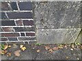
Ordnance Survey Cut Mark
This OS cut mark can be found on the SE parapet of the railway bridge on Bridge Road. It marks a point 46.732m above mean sea level.
Image: © Adrian Dust
Taken: 2 Dec 2022
0.03 miles
7
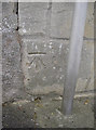
Benchmark on Bridge Road
A cutmark on the parapet of the railway bridge, as listed in the Database: http://www.bench-marks.org.uk/bm39812 . See Image] for a view from the other direction.
Image: © Neil Owen
Taken: 17 Oct 2011
0.04 miles
8
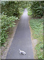
Dog on the path
A four-legged user enjoys the scenery along the old railway path. Formerly the line from Green Park, it was shut in the 1960's, and is now a useful (and quieter) path. Taken from the bridge in Bridge Road.
Image: © Neil Owen
Taken: 17 Oct 2011
0.04 miles
9

Bath : Two Tunnels Greenway
A footpath heads underneath Bridge Road.
Image: © Lewis Clarke
Taken: 6 Aug 2020
0.05 miles
10
Benchmark in Oldfield Park
A benchmark (as listed in the Database http://www.bench-marks.org.uk/bm39811 ) can be found in West Avenue at the junction with Bridge Road. See Image] for a wider view.
Image: © Neil Owen
Taken: 17 Oct 2011
0.05 miles