IMAGES TAKEN NEAR TO
Conygre Green, BATH, BA2 0JU
Introduction
This page details the photographs taken nearby to Conygre Green, BA2 0JU by members of the Geograph project.
The Geograph project started in 2005 with the aim of publishing, organising and preserving representative images for every square kilometre of Great Britain, Ireland and the Isle of Man.

There are currently over 7.5m images from over14,400 individuals and you can help contribute to the project by visiting https://www.geograph.org.uk
Image Map
Images are licensed for reuse under creativecommons.org/licenses/by-sa/2.0
Notes
- Clicking on the map will re-center to the selected point.
- The higher the marker number, the further away the image location is from the centre of the postcode.
Image Listing (62 Images Found)
Images are licensed for reuse under creativecommons.org/licenses/by-sa/2.0
Image
Details
Distance
1
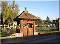
Timsbury burials
The village has a number of churches but this burial ground is distinctly separate from them. The original plot was acquired around the turn of the century, close to the Conygre Colliery, and was about one third of the current size. The lychgate marks the entrance. See Image] for another view.
Image: © Neil Owen
Taken: 9 Feb 2015
0.06 miles
2
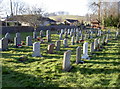
Timsbury burial ground
Looking across the rows of graves and on to the lychgate at the far end, the grounds were enlarged before WWII. Today there is precious little space left and moves are being made to find a new cemetery. See Image] for the lychgate.
Image: © Neil Owen
Taken: 9 Feb 2015
0.06 miles
3
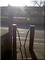
A certain stile
The path alongside the burial grounds on The Avenue has a characteristic set of bollards to prevent larger traffic. There are a number of similar ones dotted around the village.
Image: © Neil Owen
Taken: 9 Feb 2015
0.07 miles
4
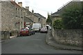
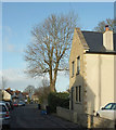
2007 : High Street, Timsbury
Timsbury is mentioned in the Domesday Book.
From about 1800 it was a mining town in the North Somerset coalfield, this has now ceased.
St. Mary's Church is at the far end of High Street.
Image: © Maurice Pullin
Taken: 10 Jul 2007
0.07 miles
5
House on Newmans Lane, Timsbury
A new house north of The Square.
Image: © Derek Harper
Taken: 9 Dec 2019
0.07 miles
6
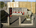
Timsbury's fallen
The small but well-tended memorial in the grounds of the British Legion recounts those who were lost in war. Interestingly enough, there are more names in the Great War than the later.
Image: © Neil Owen
Taken: 9 Feb 2015
0.07 miles
7
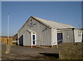
Timsbury Legion
The Royal British Legion occupies a noticeably corrugated building. Formerly, it was the Church Room, paid for and built by public subscription
Image: © Neil Owen
Taken: 9 Feb 2015
0.07 miles
8
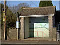
A landscape whilst waiting
A bus shelter, complete with a pleasing landscape.
Image: © Neil Owen
Taken: 9 Feb 2015
0.08 miles
9
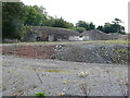
Site of Demolished Works
This is the site of the former works of the Wheeler Reconstructed Stone Company which produces artificial stone from a mix of cement and crushed Bath stone.This is used in new build house projects as a cheap replacement for natural stone. They appear to have relocated to Marsh Lane, Temple Cloud but it is uncertain if they are still manufacturing. In this image it can be seen that on the remaining site there appears to be evidence of an old kiln , perhaps a lime kiln.
Image: © Nigel Mykura
Taken: 18 Sep 2011
0.08 miles
10
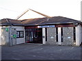
Conygre Hall
Timsbury was, for much of its latter history, a mining village. With the easing of legal restrictions in the 1920s to provide a means of help and assistance for miners, a plot of land was acquired as a recreation ground. Following concerted fund-raising, the hall was built and opened on 26th May, 1973. The Conygre Trust (in recognition of the old Conygre Colliery) was set up in 2005 to run the various indoor and outdoor facilities.
Image: © Neil Owen
Taken: 9 Feb 2015
0.08 miles